IMAGES TAKEN NEAR TO
Edgefield Drive, CRAMLINGTON, NE23 3HZ
Introduction
This page details the photographs taken nearby to Edgefield Drive, NE23 3HZ by members of the Geograph project.
The Geograph project started in 2005 with the aim of publishing, organising and preserving representative images for every square kilometre of Great Britain, Ireland and the Isle of Man.

There are currently over 7.5m images from over14,400 individuals and you can help contribute to the project by visiting https://www.geograph.org.uk
Image Map (Loading...)


Getting Data...Please wait
Leaflet Map data © OpenStreetMap
Images are licensed for reuse under creativecommons.org/licenses/by-sa/2.0
Notes
- Clicking on the map will re-center to the selected point.
- The higher the marker number, the further away the image location is from the centre of the postcode.
Image Listing (6 Images Found)
Images are licensed for reuse under creativecommons.org/licenses/by-sa/2.0
Image
Details
Distance
2
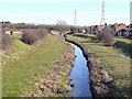
Horton Burn
Exiting the north-east corner of Cramlington, flanked by the modern housing estates of Shankhouse. A view of the same burn a short way upstream can be seen in Image The B1505 can be seen beyond, with the embankment carrying the A189 in the distance.
Image: © Oliver Dixon
Taken: 2 Mar 2010
0.09 miles
3
Footpath at Shankhouse
Sadly, a closed footpath (reason unknown) just to the north of the fire station at Shankhouse, Blyth, Northumberland.
Image: © Grahame Jenkins
Taken: 26 Jan 2006
0.13 miles
5
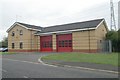
Cramlington fire station
Cramlington fire station, Albion Road, Shankhouse, Cramlington, Northumberland
Image: © Kevin Hale
Taken: 3 Aug 2010
0.18 miles
6
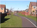
Cycleway, Shankhouse
There are a number of cycleways incorporated into the fabric of Cramlington new town. This one lies just north of Durham Road.
Image: © Oliver Dixon
Taken: 2 Mar 2010
0.22 miles