IMAGES TAKEN NEAR TO
Ringwood Drive, CRAMLINGTON, NE23 1ND
Introduction
This page details the photographs taken nearby to Ringwood Drive, NE23 1ND by members of the Geograph project.
The Geograph project started in 2005 with the aim of publishing, organising and preserving representative images for every square kilometre of Great Britain, Ireland and the Isle of Man.

There are currently over 7.5m images from over14,400 individuals and you can help contribute to the project by visiting https://www.geograph.org.uk
Image Map
Images are licensed for reuse under creativecommons.org/licenses/by-sa/2.0
Notes
- Clicking on the map will re-center to the selected point.
- The higher the marker number, the further away the image location is from the centre of the postcode.
Image Listing (4 Images Found)
Images are licensed for reuse under creativecommons.org/licenses/by-sa/2.0
Image
Details
Distance
1
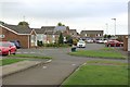
Eastfield Chase, Cramlington
Part of a housing estate, the houses are of a similar age to much of the town.
Image: © Graham Robson
Taken: 19 Aug 2018
0.18 miles
2
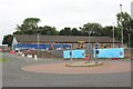
Aldi supermarket, Cramlington
The Aldi supermarket in Cramlington off the B1326. The store is in the middle of a short closure period whilst it is refurbished and extended.
Image: © Graham Robson
Taken: 19 Aug 2018
0.18 miles
3
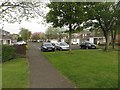
Romsey Close, Cramlington
A residential street close to Cramlington town centre.
Image: © Graham Robson
Taken: 15 May 2016
0.22 miles
4
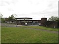
Shanklea Primary School, Cramlington
One of several primary schools in Cramlington.
Image: © Graham Robson
Taken: 15 May 2016
0.23 miles