IMAGES TAKEN NEAR TO
Grosvenor Avenue, NEWCASTLE UPON TYNE, NE2 2NP
Introduction
This page details the photographs taken nearby to Grosvenor Avenue, NE2 2NP by members of the Geograph project.
The Geograph project started in 2005 with the aim of publishing, organising and preserving representative images for every square kilometre of Great Britain, Ireland and the Isle of Man.

There are currently over 7.5m images from over14,400 individuals and you can help contribute to the project by visiting https://www.geograph.org.uk
Image Map
Images are licensed for reuse under creativecommons.org/licenses/by-sa/2.0
Notes
- Clicking on the map will re-center to the selected point.
- The higher the marker number, the further away the image location is from the centre of the postcode.
Image Listing (86 Images Found)
Images are licensed for reuse under creativecommons.org/licenses/by-sa/2.0
Image
Details
Distance
2
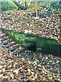
St Mary's Well
The well is 100m west of St Mary's Chapel in a small enclosure. The word 'GRATIA' is engraved on its portal. The water is clear, smells slightly sulphurous but tastes OK. A small streamlet issues from it and then disappears down a drain at the northern end. It's listed as a Scheduled Monument
https://historicengland.org.uk/listing/the-list/list-entry/1018641?section=official-list-entry
See also
https://www.megalithic.co.uk/article.php?sid=45380
Image: © Leanmeanmo
Taken: 3 Dec 2022
0.03 miles
3
St Mary's Well
The well is 100m west of St Mary's Chapel in a small enclosure. The word 'GRATIA' can be seen here engraved on its portal. The water is clear, smells slightly sulphurous but tastes OK. A small streamlet issues from it and then disappears down a drain at the northern end. It's listed as a Scheduled Monument
https://historicengland.org.uk/listing/the-list/list-entry/1018641?section=official-list-entry
See also
https://www.megalithic.co.uk/article.php?sid=45380
Image: © Leanmeanmo
Taken: 3 Dec 2022
0.03 miles
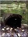
4

St Mary's Well: interior
The well is 100m west of St Mary's Chapel in a small enclosure. The word 'GRATIA' is engraved on its portal. The water is clear, smells slightly sulphurous but tastes OK. A small streamlet issues from it and then disappears down a drain at the northern end. It's listed as a Scheduled Monument
https://historicengland.org.uk/listing/the-list/list-entry/1018641?section=official-list-entry
See also
https://www.megalithic.co.uk/article.php?sid=45380
Image: © Leanmeanmo
Taken: 3 Dec 2022
0.03 miles
5
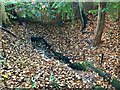
St Mary's Well
The well is 100m west of St Mary's Chapel in a small enclosure. The word 'GRATIA' is engraved on its portal. The water is clear, smells slightly sulphurous but tastes OK. A small streamlet issues from it and then disappears down a drain at the northern end (top of photo). It's listed as a Scheduled Monument
https://historicengland.org.uk/listing/the-list/list-entry/1018641?section=official-list-entry
See also
https://www.megalithic.co.uk/article.php?sid=45380
Image: © Leanmeanmo
Taken: 3 Dec 2022
0.04 miles
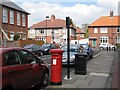
6
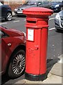
Victorian postbox, Manor House Road
Image: © Mike Quinn
Taken: 29 Apr 2009
0.05 miles
7
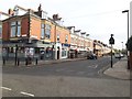
Manor House Road, Jesmond
A terrace of small shops, with flats above, in the Jesmond part of Newcastle.
Image: © Graham Robson
Taken: 14 Apr 2020
0.06 miles
8
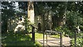
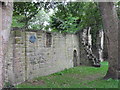
Ruins of St Mary's Chapel, Jesmond, Newcastle upon Tyne
The ruins of St Mary's Chapel sit amongst a small clump of mature trees between Reid Park Road and Jesmond Dene Road. The remnants are a scheduled monument: https://historicengland.org.uk/listing/the-list/list-entry/1018640
Image: © Graham Robson
Taken: 24 Jun 2020
0.08 miles
9
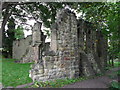
St Mary's Chapel, Jesmond
Built in the 12th Century, enlarged in the 14th. A place of pilgrimage in the Middle Ages. Sold by Edward VI to the City of Newcastle in 1549. It was returned to the City by Lord Armstrong in 1883.
Image: © Anthony Foster
Taken: 11 Sep 2011
0.09 miles
10
St Mary's Chapel, Jesmond
Built in the 12th Century, enlarged in the 14th. A place of pilgrimage in the Middle Ages. Sold by Edward VI to the City of Newcastle in 1549. It was returned to the City by Lord Armstrong in 1883.
Image: © Anthony Foster
Taken: 11 Sep 2011
0.09 miles