IMAGES TAKEN NEAR TO
Osborne Road, NEWCASTLE UPON TYNE, NE2 2AB
Introduction
This page details the photographs taken nearby to Osborne Road, NE2 2AB by members of the Geograph project.
The Geograph project started in 2005 with the aim of publishing, organising and preserving representative images for every square kilometre of Great Britain, Ireland and the Isle of Man.

There are currently over 7.5m images from over14,400 individuals and you can help contribute to the project by visiting https://www.geograph.org.uk
Image Map
Images are licensed for reuse under creativecommons.org/licenses/by-sa/2.0
Notes
- Clicking on the map will re-center to the selected point.
- The higher the marker number, the further away the image location is from the centre of the postcode.
Image Listing (155 Images Found)
Images are licensed for reuse under creativecommons.org/licenses/by-sa/2.0
Image
Details
Distance
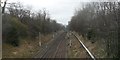
1
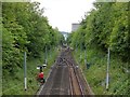
Alterations to Metro Railway line seen from Clayton Road, Jesmond
The branch to the right ahead goes to Jesmond Metro Station.
Image: © Andrew Curtis
Taken: 9 Aug 2013
0.04 miles
2
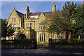
The Manor House, Jesmond
This house was built in 1887 for Arthur Sutherland, a wealthy local industrialist. The Sutherland family donated it to the City of Newcastle in 1953 and it is now the official residence of the Lord Mayor. It is also used for private functions.
Image: © Stephen McKay
Taken: 14 Feb 2016
0.04 miles
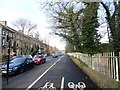
4
Eslington Terrace
A terrace in Jesmond.
The metro runs in a deep cutting on the left.
Image: © Russel Wills
Taken: 7 Apr 2021
0.05 miles
5
Tyne and Wear Metro north of Jesmond Station
This section was originally opened by the Blyth and Tyne Railway on 27 June 1864 as part of its extension from Holywell to Newcastle New Bridge Street.
The line was closed 23 January 1978 for conversion to Metro and re-opened 11 August 1980. The diversion to the new Metro station can be seen to the right.
Image: © Anthony Foster
Taken: 20 Feb 2013
0.05 miles
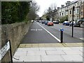
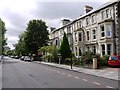
6
View along Elsington Terrace, Jesmond
This street is in the Brandling Village area of the suburb, and was built as superior middle class housing in the late 19th century. View is looking north, with the Metro line on the right.
Image: © Robert Graham
Taken: 10 Feb 2020
0.06 miles
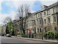
7
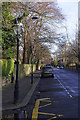
Eslington Terrace, south of Clayton Road, Jesmond
Image: © Andrew Curtis
Taken: 9 Aug 2013
0.06 miles
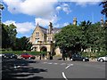
9
Fernwood Road, Jesmond
Seen here from its junction with Granville Road, Fernwood Road is part of Jesmond, a leafy Victorian suburb close to Newcastle's city centre nowadays much favoured by students and young professionals. Note the contrasting street lamps.
Image: © Stephen McKay
Taken: 14 Feb 2016
0.06 miles
