IMAGES TAKEN NEAR TO
East Sleekburn, BEDLINGTON, NE22 7AT
Introduction
This page details the photographs taken nearby to NE22 7AT by members of the Geograph project.
The Geograph project started in 2005 with the aim of publishing, organising and preserving representative images for every square kilometre of Great Britain, Ireland and the Isle of Man.

There are currently over 7.5m images from over14,400 individuals and you can help contribute to the project by visiting https://www.geograph.org.uk
Image Map
Images are licensed for reuse under creativecommons.org/licenses/by-sa/2.0
Notes
- Clicking on the map will re-center to the selected point.
- The higher the marker number, the further away the image location is from the centre of the postcode.
Image Listing (14 Images Found)
Images are licensed for reuse under creativecommons.org/licenses/by-sa/2.0
Image
Details
Distance
1
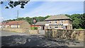
The General Havelock
Pub in East Sleekburn.
Image: © Richard Webb
Taken: 31 Jul 2012
0.03 miles
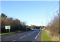
2
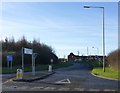
The road to East Sleekburn (west)
A village beside the Sleek Burn.
Image: © Russel Wills
Taken: 10 Feb 2016
0.16 miles
3
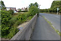
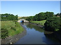
East Sleekburn Bridge
The bridge carries Moorland Avenue across the Sleek Burn.
Image: © Mat Fascione
Taken: 5 Aug 2018
0.16 miles
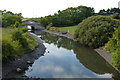
7
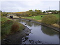
River
Burn at East Sleekburn Bridge carrying 189 Spine Road. This burn leads into the River Blyth.
Image: © george hurrell
Taken: 12 Nov 2006
0.21 miles
8
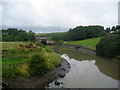
Sleek Burn
Looking upstream towards the bridge that carries the A189 trunk road.
Image: © Chris Heaton
Taken: 19 Aug 2008
0.21 miles
9
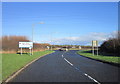
Brock Bank approaches the A189
From the East Sleekburn turning.
The pylons carry power lines from the now demolished Cambois Power Station.
Image: © Russel Wills
Taken: 10 Feb 2016
0.22 miles
10
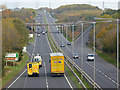
The A189 north of Bedlington
Seen from the road overbridge at Sleekburn Grange Farm. The slip roads form the connection with Brock Lane.
Image: © Oliver Dixon
Taken: 26 Oct 2015
0.22 miles