IMAGES TAKEN NEAR TO
Stanley Grove, BEDLINGTON, NE22 5NT
Introduction
This page details the photographs taken nearby to Stanley Grove, NE22 5NT by members of the Geograph project.
The Geograph project started in 2005 with the aim of publishing, organising and preserving representative images for every square kilometre of Great Britain, Ireland and the Isle of Man.

There are currently over 7.5m images from over14,400 individuals and you can help contribute to the project by visiting https://www.geograph.org.uk
Image Map
Images are licensed for reuse under creativecommons.org/licenses/by-sa/2.0
Notes
- Clicking on the map will re-center to the selected point.
- The higher the marker number, the further away the image location is from the centre of the postcode.
Image Listing (6 Images Found)
Images are licensed for reuse under creativecommons.org/licenses/by-sa/2.0
Image
Details
Distance
1
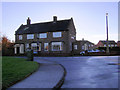
Bedlington Terrier public house
Named after Bedlington Terrier dog
Image: © george hurrell
Taken: 26 Nov 2006
0.06 miles
2
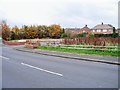
The Terrier has gone
Demolished, gone.
For as it was see http://www.geograph.org.uk/photo/284949
Image: © David Clark
Taken: 29 Oct 2010
0.06 miles
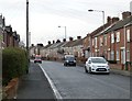
3

Terrace of houses in Poplar Grove, Bedlington
Image: © Oliver Dixon
Taken: 26 Oct 2015
0.08 miles
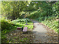
5
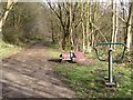
Public bridleway above the River Blyth
A public bridleway runs parallel to the River Blyth on its northern bank. Here a pair of pieces of outdoor gym equipment have been placed beside the path.
Image: © Graham Robson
Taken: 26 Feb 2017
0.16 miles
6
Fitness trail in the Dene
Just two of various items of fitness equipment sited along the path from Furnace Bridge which climbs above the Dene to reach Bedlington at Spring Park.
Image: © Oliver Dixon
Taken: 26 Oct 2015
0.17 miles