IMAGES TAKEN NEAR TO
Melrose Avenue, BEDLINGTON, NE22 5LJ
Introduction
This page details the photographs taken nearby to Melrose Avenue, NE22 5LJ by members of the Geograph project.
The Geograph project started in 2005 with the aim of publishing, organising and preserving representative images for every square kilometre of Great Britain, Ireland and the Isle of Man.

There are currently over 7.5m images from over14,400 individuals and you can help contribute to the project by visiting https://www.geograph.org.uk
Image Map
Images are licensed for reuse under creativecommons.org/licenses/by-sa/2.0
Notes
- Clicking on the map will re-center to the selected point.
- The higher the marker number, the further away the image location is from the centre of the postcode.
Image Listing (32 Images Found)
Images are licensed for reuse under creativecommons.org/licenses/by-sa/2.0
Image
Details
Distance
1
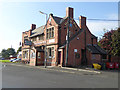
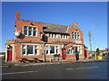
The Bank Top public house
Prominently sited public house on Stead Lane (B1331), currently up for sale.
Image: © Oliver Dixon
Taken: 26 Oct 2015
0.07 miles
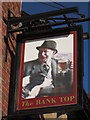
4
Public House
The Bank Top public house at the top of the Furness Bank, Bedlington Station.
Image: © george hurrell
Taken: 26 Nov 2006
0.09 miles
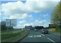
6
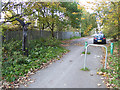
National Cycle Network route 1, Palace Road, Bedlington
National Cycle Network route 1 (Coast and Castles) follows a path up from the B1331 and here runs into the southern end of Palace Road.
To the left is one of the 1000 mileposts donated by Royal Bank of Scotland to the National Cycle Network project, see http://www.sustrans.org.uk/scotland/national-cycle-network/about-network/millenium-mileposts. There are four designs of milepost - by an Englishman, a Welshman, a Scotsman and an Irishman. The example seen here on the left is an "English" one, entitled "the Fossil Tree" and designed by John Mills.
Image: © Oliver Dixon
Taken: 26 Oct 2015
0.11 miles
7
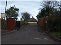
Entrance to Bowling Green & Tennis Courts
Entrance to Tennis Courts & Bowling Green off Palace Road
Image: © Kevin Richardson
Taken: 16 Mar 2008
0.12 miles
8
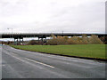
Black bridge
Railway Bridge next to Furnace Bank Bedlington Station
Image: © george hurrell
Taken: 11 Nov 2006
0.13 miles
9
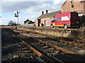
Disused Railway Station
A disused station possibly now used for storage. It's a shame that these buildings are now left to rack and ruin.
Image: © Christine Westerback
Taken: 1 Apr 2006
0.13 miles
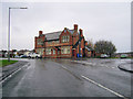
10
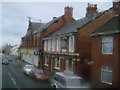
Bedlington Station Co-Op
Shops and pubs in this village based round a level crossing.
Image: © MSX
Taken: 24 Oct 2005
0.13 miles