IMAGES TAKEN NEAR TO
Park Road, BEDLINGTON, NE22 5DP
Introduction
This page details the photographs taken nearby to Park Road, NE22 5DP by members of the Geograph project.
The Geograph project started in 2005 with the aim of publishing, organising and preserving representative images for every square kilometre of Great Britain, Ireland and the Isle of Man.

There are currently over 7.5m images from over14,400 individuals and you can help contribute to the project by visiting https://www.geograph.org.uk
Image Map
Images are licensed for reuse under creativecommons.org/licenses/by-sa/2.0
Notes
- Clicking on the map will re-center to the selected point.
- The higher the marker number, the further away the image location is from the centre of the postcode.
Image Listing (38 Images Found)
Images are licensed for reuse under creativecommons.org/licenses/by-sa/2.0
Image
Details
Distance
1
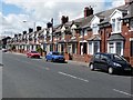
Beech Grove, Bedlington
A row of villas, possibly of Edwardian date, on the B1331.
Image: © Oliver Dixon
Taken: 13 Jul 2011
0.12 miles
2

The Church of Bedlington Christian Fellowship (2)
A view from a different direction which combined with other photo http://www.geograph.org.uk/photo/1679854 gives an idea as why it is called the Coffin Chapel.
Image: © David Clark
Taken: 26 Jan 2010
0.14 miles
4

Coffin Chapel
The Evangelist Church at Bedlington also known locally as the Coffin Chapel due to its unusual shape.
Image: © george hurrell
Taken: 2 Dec 2006
0.16 miles
5

The Church of Bedlington Christian Fellowship
Image: © JThomas
Taken: 2 Jun 2012
0.16 miles
6

The Church of Bedlington Christian Fellowship
Or The Coffin Chapel as it is known locally. Because of its shape. More modern housing surrounds it on both sides.
Image: © David Clark
Taken: 26 Jan 2010
0.16 miles
7

Head of the path to the Dene
From Spring Park, a good tarmac path descends steeply to the Dene along the river Blyth.
Image: © Oliver Dixon
Taken: 26 Oct 2015
0.17 miles
8
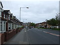
Bedlington Residential
Typical housing en route to Bedlington Station.
Image: © MSX
Taken: 24 Oct 2005
0.17 miles
9
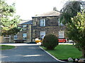
Former Manager's House, Spring View, Bedlington
This house, which is a Grade II Listed building, was once the home of the Manager of the Bedlington Iron Works which lay approximately 1 kilometre down stream. It was built in the early part of the 19th century of tooled-and-margined stone with a Welsh slate roof. It sits high above the River Blyth with excellent views eastwards.
Image: © Geoff Holland
Taken: 27 Sep 2022
0.17 miles
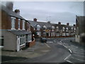
10

The Barrington Arms
Vulcan Place, Bedlington.
'The Traditional Pub'.
Image: © Russel Wills
Taken: 19 Feb 2016
0.19 miles