IMAGES TAKEN NEAR TO
Greystoke Gardens, NEWCASTLE UPON TYNE, NE2 1PT
Introduction
This page details the photographs taken nearby to Greystoke Gardens, NE2 1PT by members of the Geograph project.
The Geograph project started in 2005 with the aim of publishing, organising and preserving representative images for every square kilometre of Great Britain, Ireland and the Isle of Man.

There are currently over 7.5m images from over14,400 individuals and you can help contribute to the project by visiting https://www.geograph.org.uk
Image Map
Images are licensed for reuse under creativecommons.org/licenses/by-sa/2.0
Notes
- Clicking on the map will re-center to the selected point.
- The higher the marker number, the further away the image location is from the centre of the postcode.
Image Listing (80 Images Found)
Images are licensed for reuse under creativecommons.org/licenses/by-sa/2.0
Image
Details
Distance
1
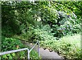
Steps at Jesmond Vale
An uphill path and a flight of concrete steps lead up from the bottom of the vale beside the Ouseburn up to Jesmond Vale Road.
Image: © Robert Graham
Taken: 15 Jul 2024
0.05 miles
2
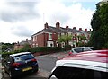
Suburban streets in Jesmond Vale
Part of the large suburb of Jesmond in Newcastle upon Tyne. This shows the junction of Greystoke Grove with Greystoke Gardens.
Image: © Robert Graham
Taken: 15 Jul 2024
0.06 miles
3
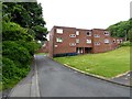
Vale Walk
Block of flats in Jesmond Vale - the one part of Jesmond Dene where a significant amount of housing has been built.
Image: © Oliver Dixon
Taken: 23 Jun 2017
0.09 miles
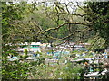
4

Jesmond Vale
The pleasant leafy surroundings of Jesmond Vale through which runs the Ouseburn which also forms Jesmond Dene, a mile or so North, which was formerly owned by armaments manufacturer Lord Armstrong.
Image: © Chris Bell
Taken: Unknown
0.09 miles
5
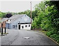
The Bluebell, Jesmond Vale
This is the only survivor of three pubs in the old Victorian village of Jesmond Vale, which was mainly cleared for slum clearance in the 1960's.
Image: © Robert Graham
Taken: 15 Jul 2024
0.10 miles
6
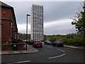
Vale House, Jesmond, Newcastle upon Tyne
Looking along Lansdowne Gardens towards the incongruous Vale House which looms over the adjacent 19th century terraces and lower end of Jesmond Dene.
Image: © Graham Robson
Taken: 26 Apr 2020
0.10 miles
8
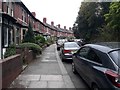
Rosebery Crescent, Jesmond, Newcastle upon Tyne
A gently curving residential street in the Jesmond area of Newcastle.
Image: © Graham Robson
Taken: 26 Apr 2020
0.14 miles
9
Helmsley Road / Goldspink Lane (2)
Shows the location of Image
Image: © Mike Quinn
Taken: 29 Apr 2009
0.14 miles
10
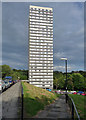
Vale House, Lansdowne Gardens, Newcastle
At 262 feet, this point block is Newcastle's tallest building. Quite slender, its "poured profiled concrete panels ... formed using shuttering designed by Derwent Wise", brother of the architect, Douglass Wise. Built 1966-68.
Another view: Image
Image: © Stephen Richards
Taken: 16 Aug 2012
0.14 miles