IMAGES TAKEN NEAR TO
Noel Avenue, BLAYDON-ON-TYNE, NE21 6SH
Introduction
This page details the photographs taken nearby to Noel Avenue, NE21 6SH by members of the Geograph project.
The Geograph project started in 2005 with the aim of publishing, organising and preserving representative images for every square kilometre of Great Britain, Ireland and the Isle of Man.

There are currently over 7.5m images from over14,400 individuals and you can help contribute to the project by visiting https://www.geograph.org.uk
Image Map
Images are licensed for reuse under creativecommons.org/licenses/by-sa/2.0
Notes
- Clicking on the map will re-center to the selected point.
- The higher the marker number, the further away the image location is from the centre of the postcode.
Image Listing (10 Images Found)
Images are licensed for reuse under creativecommons.org/licenses/by-sa/2.0
Image
Details
Distance
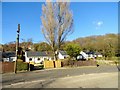
1
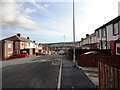
View down Mill Lane, Winlaton Mill
This road leads down the valley side into the village from Winlaton. The south side of the Derwent Valley visible beyond the houses.
Image: © Robert Graham
Taken: 30 Oct 2013
0.12 miles
2
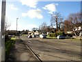
Spa Well Road, Winlaton Mill
This is a view looking south down the A694, the main road which runs along the eastside of the village. It is the main road from Dunston to Consett.
Image: © Robert Graham
Taken: 3 Feb 2016
0.12 miles
3
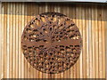
Heritage Centre and caf? shrub, Winlaton Mill (detail)
Land of Oak and Iron wall mural.
See wider image here Image
Image: © Andrew Curtis
Taken: 8 Aug 2019
0.13 miles
4
Heritage Centre and caf? shrub, Winlaton Mill (detail)
See wider image here Image
Image: © Andrew Curtis
Taken: 8 Aug 2019
0.13 miles
5
Landswood Terrace, Winlaton Mill
A row of bungalows along the main A694 which forms the east side of the village.
Image: © Robert Graham
Taken: 3 Feb 2016
0.13 miles
6
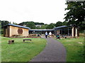
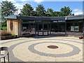
Heritage Centre and caf? shrub, Winlaton Mill
This £1.5m new visitor attraction for the Derwent Valley was officially opened by Ian Brown, Chair of Groundwork, Jill Green, Mayor of Gateshead and John Rundle from Land of Oak & Iron in October 2018. The design for the centre was inspired by a concept from Northumbria University Architecture student, Matthew Glover, based on a water wheel.
The building won the Best Small Commercial Project category at the Local Authority Building Control (LABC) Northern Awards in July 2019.
Image: © Andrew Curtis
Taken: 8 Aug 2019
0.13 miles
7
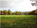
Pasture beside Lands Wood
On the north side of Winlaton Mill village.
Image: © Robert Graham
Taken: 30 Oct 2013
0.18 miles
8
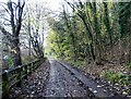
Path to Clockburn
Path leading down from the road beside The Red Kite pub at Winlaton Mill to the country park.
Image: © Robert Graham
Taken: 21 Nov 2022
0.19 miles
9
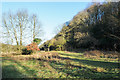
Roughly vegetated land beside River Derwent
A narrow stretch of flat land between the river and the steeply rising eastern slope of its valley.
Image: © Trevor Littlewood
Taken: 1 Jan 2019
0.21 miles
10
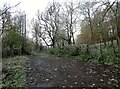
Path through the woods at Clockburn
Path to the Derwent Walk Country Park from the road at Winlaton Mill. Viewed on a rather misty autumn morning.
Image: © Robert Graham
Taken: 21 Nov 2022
0.24 miles