IMAGES TAKEN NEAR TO
BLAYDON-ON-TYNE, NE21 6LB
Introduction
This page details the photographs taken nearby to NE21 6LB by members of the Geograph project.
The Geograph project started in 2005 with the aim of publishing, organising and preserving representative images for every square kilometre of Great Britain, Ireland and the Isle of Man.

There are currently over 7.5m images from over14,400 individuals and you can help contribute to the project by visiting https://www.geograph.org.uk
Image Map
Images are licensed for reuse under creativecommons.org/licenses/by-sa/2.0
Notes
- Clicking on the map will re-center to the selected point.
- The higher the marker number, the further away the image location is from the centre of the postcode.
Image Listing (2 Images Found)
Images are licensed for reuse under creativecommons.org/licenses/by-sa/2.0
Image
Details
Distance
1
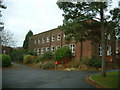
Royal Mail
Just outside the "Reception" (not in shot) lies a post box for the whole Care Village. Much to my astonishment, a Royal Mail van came whilst I was there... (not one to denigrate Royal Mail, but surprised that the post box was still in use given the lack of residents!).
In the background is another of the dilapidated homes.
Image: © Steve McShane
Taken: 28 Jan 2006
0.17 miles
2
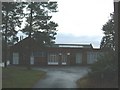
Pinewoods Reception
The deserted reception block for the care village.
Image: © Steve McShane
Taken: 28 Jan 2006
0.17 miles