IMAGES TAKEN NEAR TO
Crowley Gardens, BLAYDON-ON-TYNE, NE21 5EJ
Introduction
This page details the photographs taken nearby to Crowley Gardens, NE21 5EJ by members of the Geograph project.
The Geograph project started in 2005 with the aim of publishing, organising and preserving representative images for every square kilometre of Great Britain, Ireland and the Isle of Man.

There are currently over 7.5m images from over14,400 individuals and you can help contribute to the project by visiting https://www.geograph.org.uk
Image Map
Images are licensed for reuse under creativecommons.org/licenses/by-sa/2.0
Notes
- Clicking on the map will re-center to the selected point.
- The higher the marker number, the further away the image location is from the centre of the postcode.
Image Listing (7 Images Found)
Images are licensed for reuse under creativecommons.org/licenses/by-sa/2.0
Image
Details
Distance
5
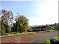
Looking east from Shibdon Bank
This bank runs south from Blaydon up to Winlaton. Good views from near the top make the long climb worthwhile. Here, the Sheriff Hill area of Gateshead can be seen.
Image: © Robert Graham
Taken: 30 Oct 2013
0.20 miles
6
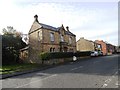
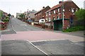
Tyne View House, Winlaton
This fine Victorian mansion ha a date of 1870 carved on the door lintel. View is looking west along Tyne Street towards the village centre.
Image: © Robert Graham
Taken: 30 Oct 2013
0.24 miles