IMAGES TAKEN NEAR TO
Path Head, BLAYDON-ON-TYNE, NE21 4SR
Introduction
This page details the photographs taken nearby to Path Head, NE21 4SR by members of the Geograph project.
The Geograph project started in 2005 with the aim of publishing, organising and preserving representative images for every square kilometre of Great Britain, Ireland and the Isle of Man.

There are currently over 7.5m images from over14,400 individuals and you can help contribute to the project by visiting https://www.geograph.org.uk
Image Map
Images are licensed for reuse under creativecommons.org/licenses/by-sa/2.0
Notes
- Clicking on the map will re-center to the selected point.
- The higher the marker number, the further away the image location is from the centre of the postcode.
Image Listing (26 Images Found)
Images are licensed for reuse under creativecommons.org/licenses/by-sa/2.0
Image
Details
Distance
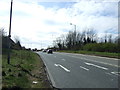
1

Path Head near Blaydon
Path Head Farm is on the right, off Hexham Old Road.
Image: © Andrew Curtis
Taken: 19 Feb 2012
0.00 miles
3
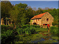
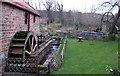
Path Head Water Mill, Summerhill, Blaydon on Tyne
A heritage site and working museum. The water wheel is restored and operational. The corn mill dates from 1730.
Image: © wfmillar
Taken: 14 May 2014
0.06 miles
4
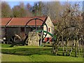
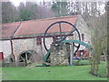
Path Head Water Mill, Blaydon
Path Head Mill is an C18th water mill restored by The Vale Mill Trust founded in 1992, to promote awareness of heritage in the community. The mill was opened to the public in 1998 and is regularly used by Schools and Special Needs groups. The mill was restored using machinery from other Northumbrian mills and they have also installed woodworking machinery. Among the range of attractions, they have a growing willow house (right) and flywheel & crankshaft display (central). The mill pond has been opened up to visitors with several islands connected by bridges. They have also restored a wind pump which, along with a hydraulic ram pump, and water and wind turbines, are used to demonstrate alternative renewable energy.
http://gatesheadmill.co.uk/index.html
Image: © Andrew Curtis
Taken: 19 Feb 2012
0.06 miles
5
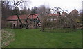
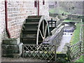
Path Head Water Mill
There is record of a mill called the Stella Freehold Mill in 1633 in the area of Path Head Water Mill. The current building dates from 1728.
Image: © David Rogers
Taken: 21 Mar 2009
0.07 miles
6
Path Head Water Mill
Restored 18th century watermill at Path Head above Stella.
Image: © David Rogers
Taken: 21 Mar 2009
0.08 miles
9
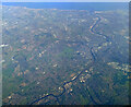
Newcastle from the air
Most of the city can be seen in this view.
Taken at around 37,000 feet by mobile phone, from a Prague bound flight from Edinburgh.
Image: © Thomas Nugent
Taken: 10 Oct 2022
0.12 miles
10
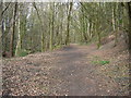
Route of Towneley Main Waggonway
Looking downhill on the route of the waggonway on which coal from Emma Pit and Stargate Pit was transported to Stella Staith on the River Tyne.
Image: © Adrian Featherstone
Taken: 22 Apr 2013
0.13 miles