IMAGES TAKEN NEAR TO
Mosspool, BLAYDON-ON-TYNE, NE21 4HD
Introduction
This page details the photographs taken nearby to Mosspool, NE21 4HD by members of the Geograph project.
The Geograph project started in 2005 with the aim of publishing, organising and preserving representative images for every square kilometre of Great Britain, Ireland and the Isle of Man.

There are currently over 7.5m images from over14,400 individuals and you can help contribute to the project by visiting https://www.geograph.org.uk
Image Map
Images are licensed for reuse under creativecommons.org/licenses/by-sa/2.0
Notes
- Clicking on the map will re-center to the selected point.
- The higher the marker number, the further away the image location is from the centre of the postcode.
Image Listing (13 Images Found)
Images are licensed for reuse under creativecommons.org/licenses/by-sa/2.0
Image
Details
Distance
1
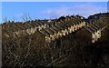
Terraced houses above Blaydon Burn valley
There is another photo here Image
Image: © Andrew Curtis
Taken: 19 Feb 2012
0.10 miles
2

Between Francis Street & Helen Street, Winlaton
Image: © Andrew Curtis
Taken: 24 Feb 2012
0.11 miles
3
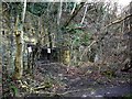
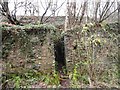
Bessie Pit Drift Mine Entrance, Blaydon Burn
First shown on the 1858 OS as a single building with enclosures to the south-west, the pit was part of Joseph Cowen’s Blaydon Burn Colliery. The pit was taken over by Priestman Collieries c.1900 and vested with the National Coal Board Northern Division in 1947. It was closed in 1950.
Image: © Andrew Curtis
Taken: 24 Feb 2012
0.12 miles
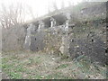
4
Retaining wall and remains of Coal Drops, Blaydon Burn
Coal from the Bessie (or Betsey) Drift Mine Image situated directly to the east, on the valley side, was carried on an elevated platform across the valley to the drops where it was loaded into waggons for transport to the Blaydon Tyne staithes. The doorway on the left has a set of steps which provided access to the upper platform. The Betsie Pit was part of Joseph Cowen's Blaydon Burn Colliery in operation in the mid C19th. Around 1900 it was taken over by Priestman Collieries and finally closed in the 1950s by the National Coal Board.
http://isee.gateshead.gov.uk/detail.php?t=objects&type=all&f=&s=+GL002203
Image: © Andrew Curtis
Taken: 19 Feb 2012
0.15 miles
6
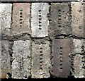
Detail of former reservoir wall, Blaydon Burn
The reservoir was built in the early C20th with unmarked red bricks. It was later partly repaired using bricks stamped with 'Cowen M'. These are fire-bricks made sometime after 1926 in Cowen's Brickworks at the east end of the valley. The factory, which opened in 1838, made 6 million fire-bricks a year. At that time a good hand moulder could make 2,400 bricks a day. The reservoir, now largely hidden by trees, may have supplied water for quenching coke, burned in ovens in the valley below, or as a general supply for Blaydon Burn Colliery.
The Cowen Brick - probably the best brick in the world http://www.rolyveitch.20m.com/CowenBrick.html
Image: © Andrew Curtis
Taken: 19 Feb 2012
0.18 miles
7
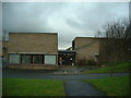
The Winlaton Centre
Community Centre that runs a host of activities for young and old. It houses a large hall, a sports hall, computer suites, even a photographic darkroom and (soon to a come) a kiln!
Image: © Steve McShane
Taken: 28 Jan 2006
0.21 miles
8
Bessie Pit Coal Drops
These are along Blaydon Burn. They were used to load coal into waggons on the railway which once ran along the burn. This is now the public footpath.
Image: © Robert Graham
Taken: 12 Dec 2012
0.22 miles
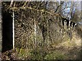
9
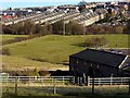
Field east of Liddells Fell Road
View to Winlaton over the corner of Greenwell Farm.
Image: © Andrew Curtis
Taken: 24 Feb 2012
0.23 miles
10
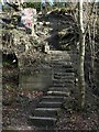
Steps on east side of Blaydon Burn valley
The steps to the north-east of the former coke cutting platform provide access to two converging tracks on the east side of the valley. To its left is a brick structure thought to be associated with former footbridge that crossed the railway lines in the valley bottom at a high level.
Image: © Andrew Curtis
Taken: 19 Feb 2012
0.23 miles