IMAGES TAKEN NEAR TO
Croftdale Road, BLAYDON-ON-TYNE, NE21 4BG
Introduction
This page details the photographs taken nearby to Croftdale Road, NE21 4BG by members of the Geograph project.
The Geograph project started in 2005 with the aim of publishing, organising and preserving representative images for every square kilometre of Great Britain, Ireland and the Isle of Man.

There are currently over 7.5m images from over14,400 individuals and you can help contribute to the project by visiting https://www.geograph.org.uk
Image Map
Images are licensed for reuse under creativecommons.org/licenses/by-sa/2.0
Notes
- Clicking on the map will re-center to the selected point.
- The higher the marker number, the further away the image location is from the centre of the postcode.
Image Listing (4 Images Found)
Images are licensed for reuse under creativecommons.org/licenses/by-sa/2.0
Image
Details
Distance
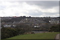
3
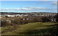
Field west of Blaydon
Taken from the path on the bank above Horse Crofts and Cochran Street just below the playing field. The path descends to the west end of Delacours Road. View of the River Tyne east of Newburn Riverside industrial estate near Lemington.
Image: © Andrew Curtis
Taken: 24 Feb 2012
0.19 miles