IMAGES TAKEN NEAR TO
Rivermede, NEWCASTLE UPON TYNE, NE20 9XA
Introduction
This page details the photographs taken nearby to Rivermede, NE20 9XA by members of the Geograph project.
The Geograph project started in 2005 with the aim of publishing, organising and preserving representative images for every square kilometre of Great Britain, Ireland and the Isle of Man.

There are currently over 7.5m images from over14,400 individuals and you can help contribute to the project by visiting https://www.geograph.org.uk
Image Map
Images are licensed for reuse under creativecommons.org/licenses/by-sa/2.0
Notes
- Clicking on the map will re-center to the selected point.
- The higher the marker number, the further away the image location is from the centre of the postcode.
Image Listing (92 Images Found)
Images are licensed for reuse under creativecommons.org/licenses/by-sa/2.0
Image
Details
Distance
1
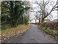
Eland Lane, Ponteland
Forming part of National Cycle Network, route 10 (the "Reivers Cycle Route").
Image: © Oliver Dixon
Taken: 28 Nov 2013
0.04 miles
2
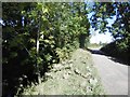
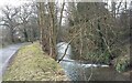
Elland Lane
River Pont (a burn) is in the trees on the left.
Image: © Richard Webb
Taken: 1 Oct 2015
0.06 miles
3
Along Eland Lane
Looking along Eland Lane leading out of Ponteland.
Image: © DS Pugh
Taken: 19 Dec 2022
0.07 miles
4
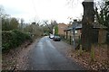
Log beside Eland Lane
Passing allotments on Eland Lane in Ponteland.
Image: © DS Pugh
Taken: 19 Dec 2022
0.08 miles
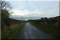
6
Cycle route sign on Eland Lane
Looking north along Eland Lane in Ponteland.
Image: © DS Pugh
Taken: 19 Dec 2022
0.10 miles
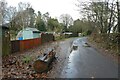
8
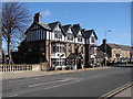
Eland Lane
Leading past the east side of the Diamond Inn to Eland Hall, and then on around the golf course.
Image: © Barbara Carr
Taken: 15 Sep 2013
0.13 miles
9
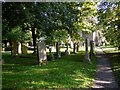
Churchyard, St Mary's Church, Ponteland
Image: © Andrew Curtis
Taken: 24 Sep 2010
0.14 miles
10
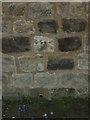
Ordnance survey benchmark
1GL Bolt Ponteland, Church
Above the GPS on the 3rd course of stones.
This bench mark was used during the First primary levelling, England & Wales, and was levelled with a height of 194.1030 feet [59.1626 metres] above mean sea level (Liverpool datum). It was included on the Newcastle-upon-Tyne to Crailing levelling line. The surveyor's description was No. 17. Bolt in South face of Ponteland Church tower ; 1.43 ft. above surface
Image: © Michael Rye
Taken: 21 May 2017
0.14 miles