IMAGES TAKEN NEAR TO
The Green, NEWCASTLE UPON TYNE, NE20 9UX
Introduction
This page details the photographs taken nearby to The Green, NE20 9UX by members of the Geograph project.
The Geograph project started in 2005 with the aim of publishing, organising and preserving representative images for every square kilometre of Great Britain, Ireland and the Isle of Man.

There are currently over 7.5m images from over14,400 individuals and you can help contribute to the project by visiting https://www.geograph.org.uk
Image Map
Images are licensed for reuse under creativecommons.org/licenses/by-sa/2.0
Notes
- Clicking on the map will re-center to the selected point.
- The higher the marker number, the further away the image location is from the centre of the postcode.
Image Listing (10 Images Found)
Images are licensed for reuse under creativecommons.org/licenses/by-sa/2.0
Image
Details
Distance
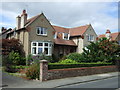
1
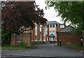
"Louisville" on North Road, Ponteland
A relatively recent development in red brick.
Image: © Helen Wilkinson
Taken: 27 May 2009
0.06 miles
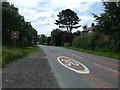
5
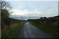
Along Eland Lane
Looking along Eland Lane leading out of Ponteland.
Image: © DS Pugh
Taken: 19 Dec 2022
0.21 miles
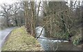
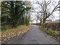
6
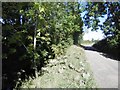
Elland Lane
River Pont (a burn) is in the trees on the left.
Image: © Richard Webb
Taken: 1 Oct 2015
0.21 miles
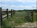
7
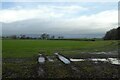
Field beside Eland Lane
Looking across a wet field of young crops near Ponteland.
Image: © DS Pugh
Taken: 19 Dec 2022
0.22 miles
9
Eland Lane, Ponteland
Forming part of National Cycle Network, route 10 (the "Reivers Cycle Route").
Image: © Oliver Dixon
Taken: 28 Nov 2013
0.23 miles
10
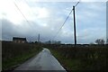
Telegraph poles along Eland Lane
On the outskirts of Ponteland.
Image: © DS Pugh
Taken: 19 Dec 2022
0.23 miles