IMAGES TAKEN NEAR TO
High Callerton, NEWCASTLE UPON TYNE, NE20 9TT
Introduction
This page details the photographs taken nearby to NE20 9TT by members of the Geograph project.
The Geograph project started in 2005 with the aim of publishing, organising and preserving representative images for every square kilometre of Great Britain, Ireland and the Isle of Man.

There are currently over 7.5m images from over14,400 individuals and you can help contribute to the project by visiting https://www.geograph.org.uk
Image Map
Images are licensed for reuse under creativecommons.org/licenses/by-sa/2.0
Notes
- Clicking on the map will re-center to the selected point.
- The higher the marker number, the further away the image location is from the centre of the postcode.
Image Listing (9 Images Found)
Images are licensed for reuse under creativecommons.org/licenses/by-sa/2.0
Image
Details
Distance
1
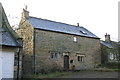
Rebellion House, High Callerton
The name comes from the tradition that Oliver Cromwell stayed in the house. It is the oldest building in the village and is basically a 17th Century Bastle House.
Image: © Phil Thirkell
Taken: 4 Jan 2006
0.08 miles
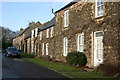
3
Callerton Hall
Entrance gate and side of the Hall.
Image: © Phil Thirkell
Taken: 4 Jan 2006
0.12 miles
4
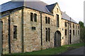
High Callerton
Farm buildings bear a date stone of 1883.
Image: © Phil Thirkell
Taken: 4 Jan 2006
0.12 miles
5
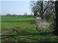
Farmland and hedgerow
East of Callerton Lane.
Image: © JThomas
Taken: 9 Apr 2015
0.16 miles
6
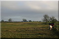
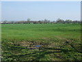
High Callerton
Fields to the east of the hamlet.
Image: © Phil Thirkell
Taken: 4 Jan 2006
0.18 miles
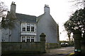
9
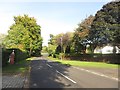
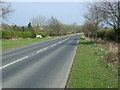
Eastern Way, Darras Hall
Looking along one of the residential streets in Darras Hall. The entire village appears to consist of detached houses set back from the road with boundaries formed by high hedges.
Image: © Graham Robson
Taken: 23 Sep 2017
0.23 miles