IMAGES TAKEN NEAR TO
High Callerton, NEWCASTLE UPON TYNE, NE20 9TS
Introduction
This page details the photographs taken nearby to NE20 9TS by members of the Geograph project.
The Geograph project started in 2005 with the aim of publishing, organising and preserving representative images for every square kilometre of Great Britain, Ireland and the Isle of Man.

There are currently over 7.5m images from over14,400 individuals and you can help contribute to the project by visiting https://www.geograph.org.uk
Image Map
Images are licensed for reuse under creativecommons.org/licenses/by-sa/2.0
Notes
- Clicking on the map will re-center to the selected point.
- The higher the marker number, the further away the image location is from the centre of the postcode.
Image Listing (2 Images Found)
Images are licensed for reuse under creativecommons.org/licenses/by-sa/2.0
Image
Details
Distance
1
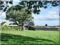
Barns at Hold House Farm
Black-painted barns as seen from the farm's access road.
Image: © Trevor Littlewood
Taken: 23 Aug 2019
0.04 miles
2
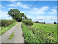
Access road for Hold House
Hold House is a farm lying south-east of Darras Hall; some of its buildings can be seen above the right hand field.
Image: © Trevor Littlewood
Taken: 23 Aug 2019
0.04 miles