IMAGES TAKEN NEAR TO
Oaklands, NEWCASTLE UPON TYNE, NE20 9PH
Introduction
This page details the photographs taken nearby to Oaklands, NE20 9PH by members of the Geograph project.
The Geograph project started in 2005 with the aim of publishing, organising and preserving representative images for every square kilometre of Great Britain, Ireland and the Isle of Man.

There are currently over 7.5m images from over14,400 individuals and you can help contribute to the project by visiting https://www.geograph.org.uk
Image Map
Images are licensed for reuse under creativecommons.org/licenses/by-sa/2.0
Notes
- Clicking on the map will re-center to the selected point.
- The higher the marker number, the further away the image location is from the centre of the postcode.
Image Listing (9 Images Found)
Images are licensed for reuse under creativecommons.org/licenses/by-sa/2.0
Image
Details
Distance
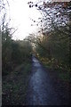
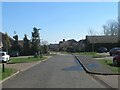
5

Darras Hall railway trackbed
Until 1929 there was a commuter service to Ponteland and onwards to Newcastle from Darras Hall.
Image: © Richard Webb
Taken: 1 Oct 2015
0.16 miles
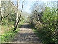
6

Reivers Cycle Route, Darras Hall
Regional Route 10 of the National Cycle Network here follows the line of an old railway which ran from Darras Hall via Ponteland to South Gosforth. The railway came very late in the railway era to Darras Hall. It only opened in 1913, was never a commercial success and closed to passengers in 1929. The line finally closed in 1954.
The old railway has the status of bridleway. A horse and cycle outrider are seen in this picture.
Image: © Oliver Dixon
Taken: 14 Feb 2011
0.16 miles
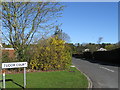
8
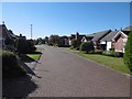
Old Station Court
The site of Darras Hall Station, which closed to passengers in 1929. Beyond here the railway was a mineral line serving Belsay Colliery.
Image: © Richard Webb
Taken: 1 Oct 2015
0.18 miles
9

Old Station Court, Darras Hall
Regional Route 10 of the National Cycle Network here follows the line of an old railway through Old Station Court. The railway to Darras Hall came very late in the railway era. It only opened in 1913, was never a commercial success and closed to passengers in 1929. The station finally closed in 1954.
Image: © Oliver Dixon
Taken: 14 Feb 2011
0.21 miles