IMAGES TAKEN NEAR TO
The Close, NEWCASTLE UPON TYNE, NE20 9PB
Introduction
This page details the photographs taken nearby to The Close, NE20 9PB by members of the Geograph project.
The Geograph project started in 2005 with the aim of publishing, organising and preserving representative images for every square kilometre of Great Britain, Ireland and the Isle of Man.

There are currently over 7.5m images from over14,400 individuals and you can help contribute to the project by visiting https://www.geograph.org.uk
Image Map
Images are licensed for reuse under creativecommons.org/licenses/by-sa/2.0
Notes
- Clicking on the map will re-center to the selected point.
- The higher the marker number, the further away the image location is from the centre of the postcode.
Image Listing (22 Images Found)
Images are licensed for reuse under creativecommons.org/licenses/by-sa/2.0
Image
Details
Distance
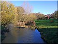
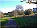
2
Park, Ponteland
Beside the River Pont and I had taken a wrong turn.
Image: © Richard Webb
Taken: 1 Oct 2015
0.17 miles
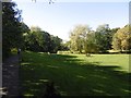
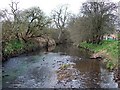
4
Ponteland Park
The River Pont is on the right and curves around to the left. The main park entrance is beyond the river to the right.
Image: © Andrew Curtis
Taken: 6 Nov 2010
0.20 miles
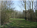
7
Looking West along river close to Ponteland Scout HQ
Image: © Newbiggin Hall Scouts
Taken: 22 Mar 2009
0.21 miles
9
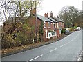
Terraced houses on West Road, Ponteland
The A696 main road from Newcastle to Jedburgh.
Image: © Oliver Dixon
Taken: 28 Nov 2013
0.21 miles
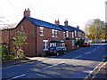
10
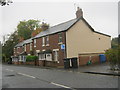
Terraced housing in West Road Ponteland
Image: © Peter Robinson
Taken: 24 Oct 2012
0.21 miles