IMAGES TAKEN NEAR TO
Matfen, NEWCASTLE UPON TYNE, NE20 0TD
Introduction
This page details the photographs taken nearby to NE20 0TD by members of the Geograph project.
The Geograph project started in 2005 with the aim of publishing, organising and preserving representative images for every square kilometre of Great Britain, Ireland and the Isle of Man.

There are currently over 7.5m images from over14,400 individuals and you can help contribute to the project by visiting https://www.geograph.org.uk
Image Map
Images are licensed for reuse under creativecommons.org/licenses/by-sa/2.0
Notes
- Clicking on the map will re-center to the selected point.
- The higher the marker number, the further away the image location is from the centre of the postcode.
Image Listing (6 Images Found)
Images are licensed for reuse under creativecommons.org/licenses/by-sa/2.0
Image
Details
Distance
2
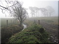
Unnamed Stream and Track leading to a Copse
Image: © Les Hull
Taken: 27 Feb 2013
0.19 miles
3
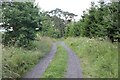
Track to the Woods
A track leading to woodland from a lane between Matfen and Great Whittington.
Image: © Jeff Buck
Taken: 13 Jul 2023
0.22 miles
4
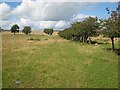
Old hedge line near Great Whittington
Seen from the road between Matfen and Great Whittington.
Image: © Oliver Dixon
Taken: 24 Aug 2008
0.25 miles
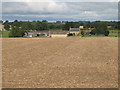
5
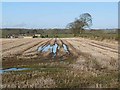
Field of stubble off Miller's Lane
Dewlaw Farm in the middle distance.
Image: © Oliver Dixon
Taken: 23 Nov 2012
0.25 miles
6
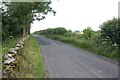
Towards Great Whittington
Heading west between Matfen and Great Whittington.
Image: © Jeff Buck
Taken: 13 Jul 2023
0.25 miles