IMAGES TAKEN NEAR TO
Robsheugh, Milbourne, NEWCASTLE UPON TYNE, NE20 0JQ
Introduction
This page details the photographs taken nearby to NE20 0JQ by members of the Geograph project.
The Geograph project started in 2005 with the aim of publishing, organising and preserving representative images for every square kilometre of Great Britain, Ireland and the Isle of Man.

There are currently over 7.5m images from over14,400 individuals and you can help contribute to the project by visiting https://www.geograph.org.uk
Image Map
Images are licensed for reuse under creativecommons.org/licenses/by-sa/2.0
Notes
- Clicking on the map will re-center to the selected point.
- The higher the marker number, the further away the image location is from the centre of the postcode.
Image Listing (9 Images Found)
Images are licensed for reuse under creativecommons.org/licenses/by-sa/2.0
Image
Details
Distance
2
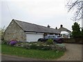
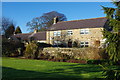
Robsheugh Farmhouse
The farm buildings have been converted into dwellings.
Image: © Les Hull
Taken: 1 May 2019
0.02 miles
3
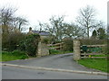
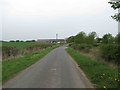
Robsheugh Farm
Entrance to Robsheugh farm house with farm house in the background
Image: © No Body
Taken: 22 Apr 2006
0.04 miles
5
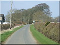
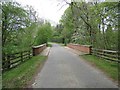
Minor road towards Black Heddon
Heading north west near Robsheugh Farm.
Image: © JThomas
Taken: 9 Apr 2015
0.08 miles
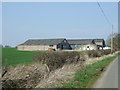
6
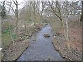
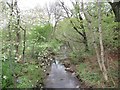
Robsheugh Burn
Looking downstream along Robsheugh Burn, which drains into the River Pont.
Image: © Oliver Dixon
Taken: 8 Apr 2010
0.09 miles