IMAGES TAKEN NEAR TO
Ponteland, NEWCASTLE UPON TYNE, NE20 0ER
Introduction
This page details the photographs taken nearby to NE20 0ER by members of the Geograph project.
The Geograph project started in 2005 with the aim of publishing, organising and preserving representative images for every square kilometre of Great Britain, Ireland and the Isle of Man.

There are currently over 7.5m images from over14,400 individuals and you can help contribute to the project by visiting https://www.geograph.org.uk
Image Map
Images are licensed for reuse under creativecommons.org/licenses/by-sa/2.0
Notes
- Clicking on the map will re-center to the selected point.
- The higher the marker number, the further away the image location is from the centre of the postcode.
Image Listing (7 Images Found)
Images are licensed for reuse under creativecommons.org/licenses/by-sa/2.0
Image
Details
Distance
1
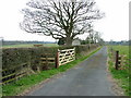
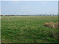
South Coldcoats Farm
Farm road to South Coldcoats farm in foreground with farm buildings in centre background
Image: © No Body
Taken: 22 Apr 2006
0.08 miles
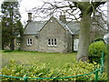
3
Milbourne Lodge
Location just off the A696 with the road to Milbourne Hall.
Image: © peter maddison
Taken: 25 Feb 2011
0.18 miles
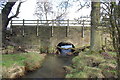
4
Milbourne Lodge
At the junction of the A696 with the minor road to Milbourne Hall
Image: © No Body
Taken: 22 Apr 2006
0.20 miles
6
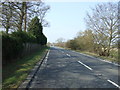
A696 near Milbourne Lodge
Looking north west.
Image: © JThomas
Taken: 9 Apr 2015
0.24 miles
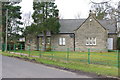
7
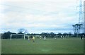
Sports Field, Northumberland College of Education
Football pitch at Northumberland College of Education playing at home in the yellow strips. Wednesday afternoons were always given over to sporting activities although everyone didn't participate. I always assumed those who didn't would rather study.
Image: © Les Hull
Taken: 15 Mar 1967
0.24 miles