IMAGES TAKEN NEAR TO
Belsay, NEWCASTLE UPON TYNE, NE20 0DP
Introduction
This page details the photographs taken nearby to NE20 0DP by members of the Geograph project.
The Geograph project started in 2005 with the aim of publishing, organising and preserving representative images for every square kilometre of Great Britain, Ireland and the Isle of Man.

There are currently over 7.5m images from over14,400 individuals and you can help contribute to the project by visiting https://www.geograph.org.uk
Image Map
Images are licensed for reuse under creativecommons.org/licenses/by-sa/2.0
Notes
- Clicking on the map will re-center to the selected point.
- The higher the marker number, the further away the image location is from the centre of the postcode.
Image Listing (9 Images Found)
Images are licensed for reuse under creativecommons.org/licenses/by-sa/2.0
Image
Details
Distance
2
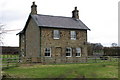
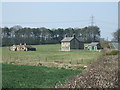
Belsay Tilery
Farmhouse just off the A696 South of Belsay.
Image: © peter maddison
Taken: 25 Feb 2011
0.03 miles
3
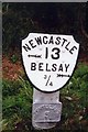
Old Milepost by the A696, Shiningpool Bridge, Whalton parish
Metal post with attached metal plate by the A696, in parish of WHALTON (CASTLE MORPETH District), North side of Shiningpool Bridge, Southeast of Belsay Tilery, on grass verge, on West side of road. Smith Patterson iron shield, erected by the Ponteland turnpike trust in the 19th century.
Inscription reads:-
NEWCASTLE
{<-arrow} 13
BELSAY
¾ {arrow->}
PONTELAND
5
Maker:-
SMITH PATTERSON
& CO
BLAYDON
Grade II listed.
List Entry Number: 1237392 https://historicengland.org.uk/listing/the-list/list-entry/1237392
Milestone Society National ID: NB_NCBS13.
Image: © IA Davison
Taken: 26 Aug 2002
0.07 miles
5
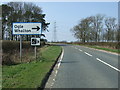
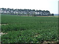
A696 towards Jedburgh
Approaching the turn off for Ogle - heading north west.
Image: © JThomas
Taken: 9 Apr 2015
0.13 miles
6
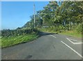
Road to Ogle
Leading north from the A696 and then turning east to the village of Ogle.
Image: © Barbara Carr
Taken: 15 Sep 2013
0.17 miles
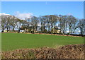
8
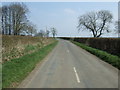
Gowk Lane near Belsay
On the right a shelterbelt, apparently consisting mostly of Scots pines.
Image: © Stephen Richards
Taken: 18 Aug 2012
0.21 miles
9
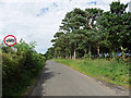
Ogle Hill Head
For Ogle 'Castle' (actually a Manor House) see Image and for a bit of Ogle history see: http://www.ogles.org/ogle.htm
Image: © Alan Fearon
Taken: 8 Feb 2006
0.24 miles