IMAGES TAKEN NEAR TO
Dissington View, NEWCASTLE UPON TYNE, NE20 0BU
Introduction
This page details the photographs taken nearby to Dissington View, NE20 0BU by members of the Geograph project.
The Geograph project started in 2005 with the aim of publishing, organising and preserving representative images for every square kilometre of Great Britain, Ireland and the Isle of Man.

There are currently over 7.5m images from over14,400 individuals and you can help contribute to the project by visiting https://www.geograph.org.uk
Image Map
Images are licensed for reuse under creativecommons.org/licenses/by-sa/2.0
Notes
- Clicking on the map will re-center to the selected point.
- The higher the marker number, the further away the image location is from the centre of the postcode.
Image Listing (11 Images Found)
Images are licensed for reuse under creativecommons.org/licenses/by-sa/2.0
Image
Details
Distance
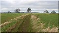

8
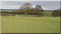
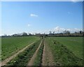
Arable land at Farrick Hill
View to Donkins House Farm between the forest plantations
Image: © Andrew Curtis
Taken: 27 Feb 2009
0.24 miles
9
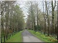
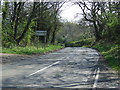
Road Through Plantation towards Dissington Old Hall
Image: © Les Hull
Taken: 28 Apr 2021
0.24 miles
10
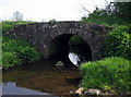
Bridge over the Med Burn
A small but perfectly constructed stone footbridge over a tributary of the River Pont.
Image: © Alan Fearon
Taken: 22 May 2007
0.25 miles