IMAGES TAKEN NEAR TO
Kirkley, NEWCASTLE UPON TYNE, NE20 0BA
Introduction
This page details the photographs taken nearby to NE20 0BA by members of the Geograph project.
The Geograph project started in 2005 with the aim of publishing, organising and preserving representative images for every square kilometre of Great Britain, Ireland and the Isle of Man.

There are currently over 7.5m images from over14,400 individuals and you can help contribute to the project by visiting https://www.geograph.org.uk
Image Map
Images are licensed for reuse under creativecommons.org/licenses/by-sa/2.0
Notes
- Clicking on the map will re-center to the selected point.
- The higher the marker number, the further away the image location is from the centre of the postcode.
Image Listing (8 Images Found)
Images are licensed for reuse under creativecommons.org/licenses/by-sa/2.0
Image
Details
Distance
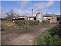
1
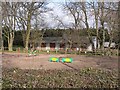
Horse exercise area at Kirkley Marsh
One of a number of horsey establishments in the area.
Image: © Oliver Dixon
Taken: 8 Apr 2010
0.00 miles
2
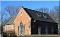
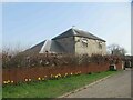
Old School House, Kirkley March
Strange to find this impressive building, beautifully restored as a private house, in this tiny hamlet. No doubt it served a large but thinly populated area
Image: © Alan Fearon
Taken: 8 Feb 2006
0.05 miles
5
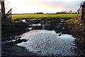
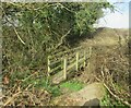
Muddy Entrance
Entrances to field often get poached and muddy at this time of year. This one was taken on a corner approaching Kirkley March which is a tiny hamlet just before Kirkley Hall Agricultural College in Northumberland
Image: © Christine Westerback
Taken: 2 Jan 2012
0.19 miles