IMAGES TAKEN NEAR TO
Ogle, NEWCASTLE UPON TYNE, NE20 0AU
Introduction
This page details the photographs taken nearby to NE20 0AU by members of the Geograph project.
The Geograph project started in 2005 with the aim of publishing, organising and preserving representative images for every square kilometre of Great Britain, Ireland and the Isle of Man.

There are currently over 7.5m images from over14,400 individuals and you can help contribute to the project by visiting https://www.geograph.org.uk
Image Map
Images are licensed for reuse under creativecommons.org/licenses/by-sa/2.0
Notes
- Clicking on the map will re-center to the selected point.
- The higher the marker number, the further away the image location is from the centre of the postcode.
Image Listing (20 Images Found)
Images are licensed for reuse under creativecommons.org/licenses/by-sa/2.0
Image
Details
Distance
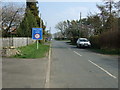
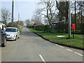
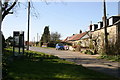
2
Entering Ogle from the east
The sum total of public facilities in this hamlet can be seen - telephone box and post box.
Image: © Oliver Dixon
Taken: 8 Apr 2010
0.03 miles
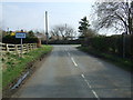
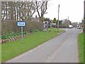
6
Minor road towards Kirkley March
Heading south from Ogle.
Image: © JThomas
Taken: 9 Apr 2015
0.06 miles
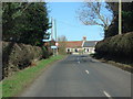
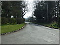
7
Approaching Ogle
The surname Ogle comes from here, where the Ogle family built Ogle Castle and owned Kirkley Hall.
Image: © Russel Wills
Taken: 1 Jun 2015
0.08 miles
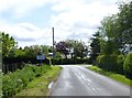
9
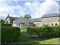
House in Ogle
Entering the village from the west.
Image: © Russel Wills
Taken: 1 Jun 2015
0.10 miles