IMAGES TAKEN NEAR TO
Shilvington, NEWCASTLE UPON TYNE, NE20 0AP
Introduction
This page details the photographs taken nearby to NE20 0AP by members of the Geograph project.
The Geograph project started in 2005 with the aim of publishing, organising and preserving representative images for every square kilometre of Great Britain, Ireland and the Isle of Man.

There are currently over 7.5m images from over14,400 individuals and you can help contribute to the project by visiting https://www.geograph.org.uk
Image Map
Images are licensed for reuse under creativecommons.org/licenses/by-sa/2.0
Notes
- Clicking on the map will re-center to the selected point.
- The higher the marker number, the further away the image location is from the centre of the postcode.
Image Listing (8 Images Found)
Images are licensed for reuse under creativecommons.org/licenses/by-sa/2.0
Image
Details
Distance

2
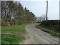
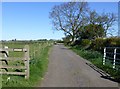
Minor road towards Shilvington
Heading south east.
Image: © JThomas
Taken: 9 Apr 2015
0.04 miles
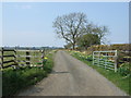
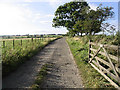

6
Minor road at Shilvington
A junction of minor roads a short distance east of Shilvington.
Image: © Graham Robson
Taken: 22 Apr 2021
0.13 miles
8
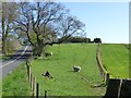
Sheep in pasture
Below Cock Hill farm.
Image: © Russel Wills
Taken: 27 Apr 2015
0.20 miles