IMAGES TAKEN NEAR TO
Kirkwhelpington, NEWCASTLE UPON TYNE, NE19 2RE
Introduction
This page details the photographs taken nearby to NE19 2RE by members of the Geograph project.
The Geograph project started in 2005 with the aim of publishing, organising and preserving representative images for every square kilometre of Great Britain, Ireland and the Isle of Man.

There are currently over 7.5m images from over14,400 individuals and you can help contribute to the project by visiting https://www.geograph.org.uk
Image Map
Images are licensed for reuse under creativecommons.org/licenses/by-sa/2.0
Notes
- Clicking on the map will re-center to the selected point.
- The higher the marker number, the further away the image location is from the centre of the postcode.
Image Listing (9 Images Found)
Images are licensed for reuse under creativecommons.org/licenses/by-sa/2.0
Image
Details
Distance
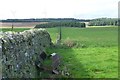
4
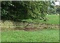
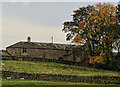
Stone stile built into wall
At Cornhills Farm.
Image: © Russel Wills
Taken: 8 Sep 2017
0.18 miles
6
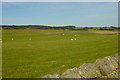
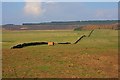
Grassland near Cornhills Farm
On the skyline, beyond the plantations, three of the sixteen giant wind turbines of the Ray Windfarm Image, opened 2017-8.
Image: © Oliver Dixon
Taken: 25 Jun 2020
0.19 miles
7
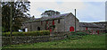
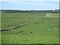
Looking towards Cornhills Farm
Upland grazing fields and small woodland
Image: © Mac McCarron
Taken: 5 Oct 2007
0.20 miles
8
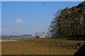
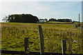
Fine dry stone wall
Pity about the agricultural junk.
Ray Fell Wind Farm beyond the forest.
Image: © Russel Wills
Taken: 8 Sep 2017
0.22 miles