IMAGES TAKEN NEAR TO
Kirkwhelpington, NEWCASTLE UPON TYNE, NE19 2RB
Introduction
This page details the photographs taken nearby to NE19 2RB by members of the Geograph project.
The Geograph project started in 2005 with the aim of publishing, organising and preserving representative images for every square kilometre of Great Britain, Ireland and the Isle of Man.

There are currently over 7.5m images from over14,400 individuals and you can help contribute to the project by visiting https://www.geograph.org.uk
Image Map (Loading...)


Getting Data...Please wait
Leaflet Map data © OpenStreetMap
Images are licensed for reuse under creativecommons.org/licenses/by-sa/2.0
Notes
- Clicking on the map will re-center to the selected point.
- The higher the marker number, the further away the image location is from the centre of the postcode.
Image Listing (7 Images Found)
Images are licensed for reuse under creativecommons.org/licenses/by-sa/2.0
Image
Details
Distance
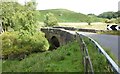
4
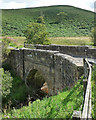
Bridge near Kirkwhelpington
With a single segmental arch, carrying a minor road over Ray Burn.
Image: © Stephen Richards
Taken: Unknown
0.18 miles
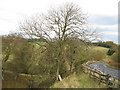
5
Bridge over the Ray Burn
Below Ray Mill and above Castle Dean.
Image: © Russel Wills
Taken: 8 Sep 2017
0.19 miles
6
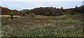
Ray Burn
Looking down Ray Burn at the head of Castle Dean.
Image: © Peter McDermott
Taken: 20 Oct 2009
0.22 miles
7
'Shoe Tree' near Knowesgate
To date, nine pairs of boots and shoes have been hurled into this ash tree near Knowesgate. Can anyone enlighten me as to why?
The following shoe tree links have been kindly supplied to me by Evelyn: http://www.mslexia.co.uk/newwriting/newwriting24.html and http://www.metro.co.uk/news/article.html?in_article_id=34336&in_page_id=34 and http://www.eglobe1.com/index.php/2006/08/10/shoes-tree/
Image: © Pete Saunders
Taken: 27 Oct 2007
0.25 miles