IMAGES TAKEN NEAR TO
Harle, NEWCASTLE UPON TYNE, NE19 2PH
Introduction
This page details the photographs taken nearby to NE19 2PH by members of the Geograph project.
The Geograph project started in 2005 with the aim of publishing, organising and preserving representative images for every square kilometre of Great Britain, Ireland and the Isle of Man.

There are currently over 7.5m images from over14,400 individuals and you can help contribute to the project by visiting https://www.geograph.org.uk
Image Map
Images are licensed for reuse under creativecommons.org/licenses/by-sa/2.0
Notes
- Clicking on the map will re-center to the selected point.
- The higher the marker number, the further away the image location is from the centre of the postcode.
Image Listing (5 Images Found)
Images are licensed for reuse under creativecommons.org/licenses/by-sa/2.0
Image
Details
Distance
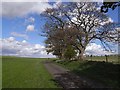
2
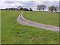
Northside Farm
Accessed by a very minor road from Kirkwhelpington.
Image: © Oliver Dixon
Taken: 26 Apr 2009
0.01 miles
3
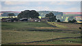
Northside Farm
A somewhat distant view of Northside Farm across the field.
Image: © Oliver Dixon
Taken: 23 Nov 2007
0.02 miles
4
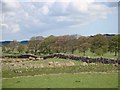
Undulating dry stone wall
Near West Harle.
Image: © Joan Sykes
Taken: 26 Apr 2009
0.14 miles
5
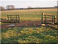
St Oswald's Way at West Harle
St Oswald's Way http://www.stoswaldsway.com/home.html is a 156 Km long trail which runs from Heavenfield near Hexham to Holy Island on the Northumberland coast (although more commonly walked in the opposite direction). Here, the Way follows a very minor road linking West Harle to the village of Kirkwhelpington.
Image: © Oliver Dixon
Taken: 26 Apr 2009
0.20 miles