IMAGES TAKEN NEAR TO
Hallington, NEWCASTLE UPON TYNE, NE19 2LW
Introduction
This page details the photographs taken nearby to NE19 2LW by members of the Geograph project.
The Geograph project started in 2005 with the aim of publishing, organising and preserving representative images for every square kilometre of Great Britain, Ireland and the Isle of Man.

There are currently over 7.5m images from over14,400 individuals and you can help contribute to the project by visiting https://www.geograph.org.uk
Image Map
Images are licensed for reuse under creativecommons.org/licenses/by-sa/2.0
Notes
- Clicking on the map will re-center to the selected point.
- The higher the marker number, the further away the image location is from the centre of the postcode.
Image Listing (31 Images Found)
Images are licensed for reuse under creativecommons.org/licenses/by-sa/2.0
Image
Details
Distance
1
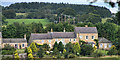
Hallington
Hallington Village seen from South Farm.
Image: © Peter McDermott
Taken: 21 Aug 2011
0.02 miles
4
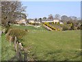
Hallington village
Seen from the south.
Image: © Oliver Dixon
Taken: 20 Apr 2009
0.05 miles
5
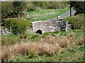
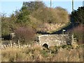
Bridge at Hallington
On the lane to Hallington New House.
Image: © Joan Sykes
Taken: 20 Apr 2009
0.06 miles
7
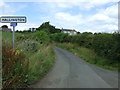
Entering Hallington
Heading north on National Cycle Route 10.
Image: © JThomas
Taken: 8 Aug 2015
0.06 miles
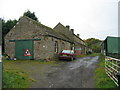
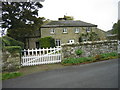
8
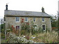
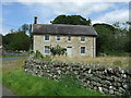
House at Hallington
This may have been a farmhouse and at present it isn't occupied.
Image: © Les Hull
Taken: 14 Oct 2009
0.06 miles
10
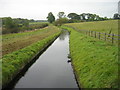
Hallington Reservoir Watercourse near Hallington
Image: © Les Hull
Taken: 14 Oct 2009
0.09 miles