IMAGES TAKEN NEAR TO
Bingfield, NEWCASTLE UPON TYNE, NE19 2LF
Introduction
This page details the photographs taken nearby to NE19 2LF by members of the Geograph project.
The Geograph project started in 2005 with the aim of publishing, organising and preserving representative images for every square kilometre of Great Britain, Ireland and the Isle of Man.

There are currently over 7.5m images from over14,400 individuals and you can help contribute to the project by visiting https://www.geograph.org.uk
Image Map (Loading...)


Getting Data...Please wait
Leaflet Map data © OpenStreetMap
Images are licensed for reuse under creativecommons.org/licenses/by-sa/2.0
Notes
- Clicking on the map will re-center to the selected point.
- The higher the marker number, the further away the image location is from the centre of the postcode.
Image Listing (16 Images Found)
Images are licensed for reuse under creativecommons.org/licenses/by-sa/2.0
Image
Details
Distance
1
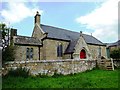
St Mary's Church
St Mary's Church in Bingfield.
Image: © Peter McDermott
Taken: 26 Dec 2011
0.05 miles
3
Bingfield
Looking directly towards Image (photographed by Bill Henderson).
Image: © Mike Quinn
Taken: 6 Apr 2013
0.05 miles
4
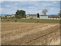
Bingfield
Bingfield was once much larger. The site of the shrunken medieval village of Bingfield, which was first recorded in the late 14th century, lies to the south of St Mary's Church Image
Pastscape: https://www.pastscape.org.uk/hob.aspx?hob_id=1448718 https://web.archive.org/web/20201029175658/https://www.pastscape.org.uk/hob.aspx?hob_id=1448718
Image: © Andrew Curtis
Taken: 28 Oct 2020
0.05 miles
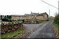
7
Bingfield
A fairly untidy collection of caravans and trailers in the grounds.
Image: © Oliver Dixon
Taken: 22 Feb 2009
0.06 miles
8
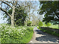
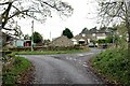
Road heading north-east from Bingfield
Bingfield itself is a tiny Northumberland settlement but the name occurs many times in its vicinity on OS maps. The image was made at the junction of minor roads in Bingfield itself where there's Bingfield Farm and West Bingfield. But following the road in the image would take one in sequence through or past Bingfield Combe Farm, Bingfield Eastside, New Bingfield and Bingfield East Quarter!
Image: © Trevor Littlewood
Taken: 29 May 2021
0.07 miles
9
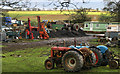
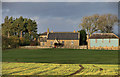
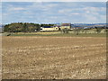
Bingfield Farm
Nice collection of tractors in the stackyard at Bingfield Farm.
Image: © Peter McDermott
Taken: 26 Dec 2011
0.07 miles
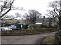
10
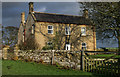
Bingfield Farm
The farmhouse at Bingfield Farm.
Image: © Peter McDermott
Taken: 26 Dec 2011
0.09 miles