IMAGES TAKEN NEAR TO
Hallington, NEWCASTLE UPON TYNE, NE19 2LB
Introduction
This page details the photographs taken nearby to NE19 2LB by members of the Geograph project.
The Geograph project started in 2005 with the aim of publishing, organising and preserving representative images for every square kilometre of Great Britain, Ireland and the Isle of Man.

There are currently over 7.5m images from over14,400 individuals and you can help contribute to the project by visiting https://www.geograph.org.uk
Image Map
Images are licensed for reuse under creativecommons.org/licenses/by-sa/2.0
Notes
- Clicking on the map will re-center to the selected point.
- The higher the marker number, the further away the image location is from the centre of the postcode.
Image Listing (3 Images Found)
Images are licensed for reuse under creativecommons.org/licenses/by-sa/2.0
Image
Details
Distance
1
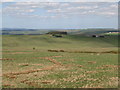
View from near Hadrian's Wall between Milecastles 23 and 24 (4: NNE)
The buildings on the first horizon (right) are at Grottington Farm on the northern edge of this grid square.
Image: © Mike Quinn
Taken: 22 Apr 2009
0.11 miles
2
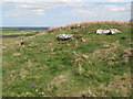
Small rock outcrop and Whittington Fell
Just to the north of the Military Road west of Milecastle 23.
Image: © Mike Quinn
Taken: 22 Apr 2009
0.13 miles
3
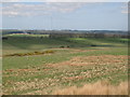
View from near Hadrian's Wall between Milecastles 23 and 24 (3: NE)
Looking towards Image (photo by Peter McDermott).
Image: © Mike Quinn
Taken: 22 Apr 2009
0.22 miles