IMAGES TAKEN NEAR TO
Capheaton, NEWCASTLE UPON TYNE, NE19 2BD
Introduction
This page details the photographs taken nearby to NE19 2BD by members of the Geograph project.
The Geograph project started in 2005 with the aim of publishing, organising and preserving representative images for every square kilometre of Great Britain, Ireland and the Isle of Man.

There are currently over 7.5m images from over14,400 individuals and you can help contribute to the project by visiting https://www.geograph.org.uk
Image Map (Loading...)


Getting Data...Please wait
Leaflet Map data © OpenStreetMap
Images are licensed for reuse under creativecommons.org/licenses/by-sa/2.0
Notes
- Clicking on the map will re-center to the selected point.
- The higher the marker number, the further away the image location is from the centre of the postcode.
Image Listing (12 Images Found)
Images are licensed for reuse under creativecommons.org/licenses/by-sa/2.0
Image
Details
Distance
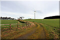
2
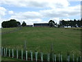
Bavington Mount
The farm has its own small wind turbine (left) and there is another much larger one to the south Image
Image: © Andrew Curtis
Taken: 12 Nov 2020
0.03 miles
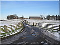
3
Bavington Mount
Bavington Mount Farm.
Image: © Peter McDermott
Taken: 21 Aug 2011
0.05 miles
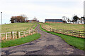
5
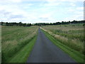
National Cycle Route 10
Heading north east towards Little Bavington.
Image: © JThomas
Taken: 8 Aug 2015
0.13 miles
8
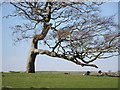
Sheep under contorted tree
Near Little Bavington.
Image: © Joan Sykes
Taken: 20 Apr 2009
0.24 miles
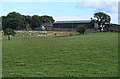
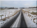
9
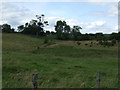
Grazing off National Cycle Route 10
Near Little Bavington.
Image: © JThomas
Taken: 8 Aug 2015
0.24 miles