IMAGES TAKEN NEAR TO
Catcleugh, NEWCASTLE UPON TYNE, NE19 1TX
Introduction
This page details the photographs taken nearby to NE19 1TX by members of the Geograph project.
The Geograph project started in 2005 with the aim of publishing, organising and preserving representative images for every square kilometre of Great Britain, Ireland and the Isle of Man.

There are currently over 7.5m images from over14,400 individuals and you can help contribute to the project by visiting https://www.geograph.org.uk
Image Map
Images are licensed for reuse under creativecommons.org/licenses/by-sa/2.0
Notes
- Clicking on the map will re-center to the selected point.
- The higher the marker number, the further away the image location is from the centre of the postcode.
Image Listing (13 Images Found)
Images are licensed for reuse under creativecommons.org/licenses/by-sa/2.0
Image
Details
Distance
1
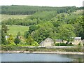
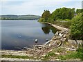
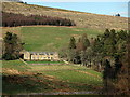
Catcleugh farm
Viewed from the reservoir dam.
At water level is a culvert carrying water from the stream in Cat Cleugh under the A68 and into the reservoir.
Image: © Russel Wills
Taken: 12 Jun 2023
0.01 miles
2
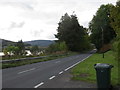
Road (A68) and Reservoir at Catcleugh
Looking westward.
Image: © Peter Wood
Taken: 9 Oct 2015
0.02 miles
3

Ordnance Survey Flush Bracket (S7656)
This OS Flush Bracket can be found on the roadside barn at Catcleugh Farm. It marks a point 825.092ft above mean sea level.
Image: © Adrian Dust
Taken: 7 Oct 2015
0.04 miles
4
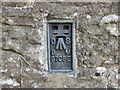
Ordnance Survey Flush Bracket S7656
This can be found on the wall of a roadside building at Catlcleugh.
For more detail see : http://www.bench-marks.org.uk/bm492
Image: © Peter Wood
Taken: 9 Oct 2015
0.04 miles
5
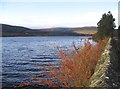
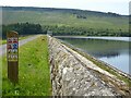
Catcleugh Reservoir
A December shot of the reservoir taken near the head of the dam by the A68.
Image: © Walter Baxter
Taken: 9 Dec 2006
0.07 miles
6
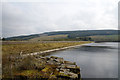
Catcleugh Reservoir
With floating debris washed up to the dam.
The reservoir was constructed between 1884 and 1905 for the Newcastle and Gateshead Water Company. The reservoir forms part of a series of reservoirs along the A68 which are connected by tunnels and aqueducts from Catcleugh Reservoir to Whittle Dene from where drinking water is supplied to Newcastle upon Tyne, Gateshead, and some surrounding areas.
Image: © Russel Wills
Taken: 12 Jun 2023
0.08 miles
7
Catcleugh Dam and reservoir
Constructed between 1884 and 1905 for the Newcastle and Gateshead Water Company. The reservoir forms part of a series of reservoirs along the A68 which are connected by tunnels and aqueducts from Catcleugh Reservoir to Whittle Dene from where drinking water is supplied to Newcastle upon Tyne, Gateshead, and some surrounding areas.
Image: © Russel Wills
Taken: 12 Jun 2023
0.14 miles
8
Dam of Catcleugh Reservoir
Catcleugh Reservoir was constructed in the early years of the twentieth century to supply water to Newcastle and Gateshead.
Image: © Trevor Littlewood
Taken: 26 Apr 2014
0.15 miles
10
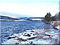
Catcleugh Reservoir
A view of the Catcleugh Reservoir from the dam wall.
Image: © James T M Towill
Taken: 20 Dec 2009
0.18 miles