IMAGES TAKEN NEAR TO
Rochester, NEWCASTLE UPON TYNE, NE19 1TD
Introduction
This page details the photographs taken nearby to NE19 1TD by members of the Geograph project.
The Geograph project started in 2005 with the aim of publishing, organising and preserving representative images for every square kilometre of Great Britain, Ireland and the Isle of Man.

There are currently over 7.5m images from over14,400 individuals and you can help contribute to the project by visiting https://www.geograph.org.uk
Image Map (Loading...)


Getting Data...Please wait
Leaflet Map data © OpenStreetMap
Images are licensed for reuse under creativecommons.org/licenses/by-sa/2.0
Notes
- Clicking on the map will re-center to the selected point.
- The higher the marker number, the further away the image location is from the centre of the postcode.
Image Listing (18 Images Found)
Images are licensed for reuse under creativecommons.org/licenses/by-sa/2.0
Image
Details
Distance
1
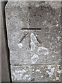
Ordnance Survey Cut Mark
This OS cut mark can be found on Burdhopecrag lodge. It marks a point 180.432m above mean sea level.
Image: © Adrian Dust
Taken: 3 Oct 2015
0.01 miles
3
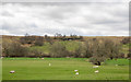
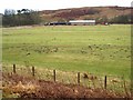
Sheep in Redesdale
The field with sheep is on the north side of the River Rede which runs at the line of trees; beyond the ground rises to moorland.
Image: © Trevor Littlewood
Taken: 22 Apr 2017
0.11 miles
4
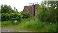
Redesdale climbing wall
The old climbing wall from when Redesdale Camp was there.
Image: © Alan Pollock
Taken: 29 Jun 2014
0.11 miles
5
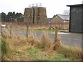
Site of Redesdale Camp
Redesdale Camp was used by Army Cadets until new facilities opened at Otterburn around 2006. The site is now wooded.
Image: © Richard Webb
Taken: 30 Dec 2016
0.12 miles
6
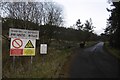
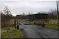
Entrance road, Redesdale Camp
Redesdale Camp is closed and demolished now, but this is an entrance to the Otterburn Range road network, much of which is open to vehicles on non firing days. A very easy way of getting into some very wild and remote country, exceptional for England.
Image: © Richard Webb
Taken: 30 Dec 2016
0.12 miles
7
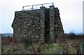
Redesdale Camp
Climbing wall at Redesdale Camp.
Image: © Peter McDermott
Taken: 30 Dec 2008
0.13 miles
8
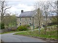
Farm buildings at Woolaw Farm
Seen from the A68 Darlington to Edinburgh road.
Image: © Oliver Dixon
Taken: 11 Jan 2008
0.16 miles
9
Assorted buildings at Redesdale Camp
Part of the MOD Otterburn Training Area http://www.army.mod.uk/ate/public/otterburn.htm , these buildings are of indeterminate purpose.
Image: © Oliver Dixon
Taken: 11 Jan 2008
0.16 miles