IMAGES TAKEN NEAR TO
Rochester, NEWCASTLE UPON TYNE, NE19 1TB
Introduction
This page details the photographs taken nearby to NE19 1TB by members of the Geograph project.
The Geograph project started in 2005 with the aim of publishing, organising and preserving representative images for every square kilometre of Great Britain, Ireland and the Isle of Man.

There are currently over 7.5m images from over14,400 individuals and you can help contribute to the project by visiting https://www.geograph.org.uk
Image Map
Images are licensed for reuse under creativecommons.org/licenses/by-sa/2.0
Notes
- Clicking on the map will re-center to the selected point.
- The higher the marker number, the further away the image location is from the centre of the postcode.
Image Listing (5 Images Found)
Images are licensed for reuse under creativecommons.org/licenses/by-sa/2.0
Image
Details
Distance
2
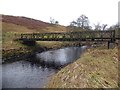
Bridge over River Rede
Allowing access to Woolaw.
Image: © Russel Wills
Taken: 5 Feb 2020
0.12 miles
3
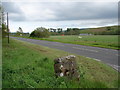
View across the A68 towards Woolaw Farm
The small signpost across the road reads "Woolaw Farm Bed & Breakfast"
Image: © Ian Paterson
Taken: 4 Jun 2007
0.13 miles
4
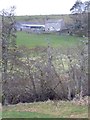
Farm buildings at Woolaw Farm
Seen from the A68 Darlington to Edinburgh road.
Image: © Oliver Dixon
Taken: 11 Jan 2008
0.14 miles
5
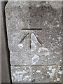
Ordnance Survey Cut Mark
This OS cut mark can be found on Burdhopecrag lodge. It marks a point 180.432m above mean sea level.
Image: © Adrian Dust
Taken: 3 Oct 2015
0.23 miles