IMAGES TAKEN NEAR TO
Leslies Drive, NEWCASTLE UPON TYNE, NE19 1HT
Introduction
This page details the photographs taken nearby to Leslies Drive, NE19 1HT by members of the Geograph project.
The Geograph project started in 2005 with the aim of publishing, organising and preserving representative images for every square kilometre of Great Britain, Ireland and the Isle of Man.

There are currently over 7.5m images from over14,400 individuals and you can help contribute to the project by visiting https://www.geograph.org.uk
Image Map
Images are licensed for reuse under creativecommons.org/licenses/by-sa/2.0
Notes
- Clicking on the map will re-center to the selected point.
- The higher the marker number, the further away the image location is from the centre of the postcode.
Image Listing (18 Images Found)
Images are licensed for reuse under creativecommons.org/licenses/by-sa/2.0
Image
Details
Distance
1
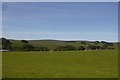
Field, Townhead
Northern side of Otterburn, looking towards the A696.
Image: © Richard Webb
Taken: 24 Jun 2018
0.19 miles
2
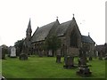
Church of St. John the Evangelist at Otterburn
Image: © James Denham
Taken: 7 Jul 2009
0.20 miles
4
Saint John The Evangelist Church, Otterburn
Three sisters, the Misses Davidson, of Lemmington Hall, and Mrs. Askew, of Pallinsburn, built Otterburn Church, in the year 1857, for the use of their tenantry and the neighbourhood. They endowed it with £100 per annum.
Image: © Russel Wills
Taken: 4 May 2018
0.21 miles
5
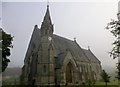
St John The Evangelist's Church, Otterburn
The foundation stone of Otterburn Church was laid on 28th September, 1855 and the Church was dedicated by the Lord Bishop of Durham on 27th October, 1857.
Image: © Rude Health
Taken: 30 Sep 2015
0.21 miles
6
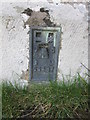
Ordnance Survey Flush Bracket (S4437)
This OS Flush Bracket can be found on the south face of St John's Church. It marks a point 153.140m above mean sea level.
Image: © Adrian Dust
Taken: 27 Sep 2015
0.22 miles
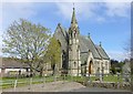
8
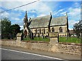
St John the Evangelist Church, Otterburn
Image: © Gordon Brown
Taken: 13 Oct 2022
0.22 miles
9
Otterburn Tower & Castle
A glimpse through the trees of this imposing building which stands beside the A696 Newcastle-Jedburgh road in Redesdale. Pevsner, who surveyed Northumberland in 1957, describes it as a "picturesque, asymmetrical, castellated mansion now in appearance mostly Victorian, but built smaller and without the west tower in the second half of the 18th century - already in the castellated style." He notes that some of the masonry of the 19th-century tower goes back to the pele tower built in the later 13th century.
Sir Walter Scott stayed at the castle in 1812 and it is thought to have provided some inspiration for his epic poem Rokeby, published in the following year. However, the poem takes its name from Rokeby Park in Image (now in County Durham, but formerly in the North Riding of Yorkshire) and is set in and around that area.
The castle is now a country hotel, restaurant and wedding venue https://www.otterburncastle.com/ and its full history can be read here https://www.otterburncastle.com/Otterburn%20Castle%20History.pdf
Image: © Tiger
Taken: 30 Nov 2019
0.22 miles
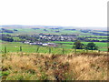
10
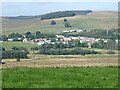
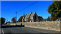
A prospect of Otterburn
Seen from the A68.
Image: © Oliver Dixon
Taken: 1 Sep 2021
0.23 miles