IMAGES TAKEN NEAR TO
Elsdon, NEWCASTLE UPON TYNE, NE19 1BL
Introduction
This page details the photographs taken nearby to NE19 1BL by members of the Geograph project.
The Geograph project started in 2005 with the aim of publishing, organising and preserving representative images for every square kilometre of Great Britain, Ireland and the Isle of Man.

There are currently over 7.5m images from over14,400 individuals and you can help contribute to the project by visiting https://www.geograph.org.uk
Image Map
Images are licensed for reuse under creativecommons.org/licenses/by-sa/2.0
Notes
- Clicking on the map will re-center to the selected point.
- The higher the marker number, the further away the image location is from the centre of the postcode.
Image Listing (19 Images Found)
Images are licensed for reuse under creativecommons.org/licenses/by-sa/2.0
Image
Details
Distance
1

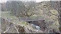
Footbridge over Raylees Burn
On public footpath to Wether Hill and West Woodburn.
Image: © Russel Wills
Taken: 31 Aug 2017
0.05 miles
2

Rayleesburn footbridge
Small wooden footbridge over the Rayleesburn
Image: © Colin Kinnear
Taken: 1 Mar 2019
0.05 miles
5

A68 at Raylees
Here the Pennine Cycleway http://www.pennine-cycleway.co.uk/ (National Cycle Network route 68) emerges from a lane to run on a cycle track (behind the crash barrier) specially constructed alongside the busy A68. The house on the hillside opposite is Shepherd's Cottage, so called as it is built around the original shepherd's cottage which belonged to the farm on the other side of the road.
Image: © Oliver Dixon
Taken: 14 Feb 2012
0.07 miles
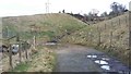
6
Junction of the Elsdon road with the A696 at Raylees
Joining the Newcastle to Jedburgh road between Belsay and Otterburn.
Image: © Stanley Howe
Taken: 22 Aug 2013
0.07 miles
7
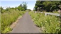
Cycle path, Raylees
Beside the A696, a rare example of a path along a busy road linking a couple of yellow roads. Much appreciated.
Image: © Richard Webb
Taken: 24 Jun 2018
0.07 miles
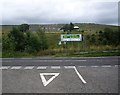
9
Raylees and the Pennine Cycleway
Hamlet beside the A68. Here the Pennine Cycleway http://www.pennine-cycleway.co.uk/ (National Cycle Network route 68) emerges from a lane to run on a cycle track alongside the busy A696.
Image: © Oliver Dixon
Taken: 14 Feb 2012
0.08 miles
10

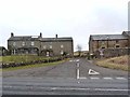
Raylees
The road to Elsdon passes through a line of buildings.
Image: © Richard Webb
Taken: 24 Jun 2018
0.08 miles