IMAGES TAKEN NEAR TO
Elsdon, NEWCASTLE UPON TYNE, NE19 1AQ
Introduction
This page details the photographs taken nearby to NE19 1AQ by members of the Geograph project.
The Geograph project started in 2005 with the aim of publishing, organising and preserving representative images for every square kilometre of Great Britain, Ireland and the Isle of Man.

There are currently over 7.5m images from over14,400 individuals and you can help contribute to the project by visiting https://www.geograph.org.uk
Image Map
Images are licensed for reuse under creativecommons.org/licenses/by-sa/2.0
Notes
- Clicking on the map will re-center to the selected point.
- The higher the marker number, the further away the image location is from the centre of the postcode.
Image Listing (3 Images Found)
Images are licensed for reuse under creativecommons.org/licenses/by-sa/2.0
Image
Details
Distance
1
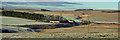
Dunshiel
Dunshiel Farm on Elsdon Burn.
Image: © Peter McDermott
Taken: 12 Jan 2008
0.01 miles
2
Rough grazing above Elsdon
Seen from the B6341 Otterburn to Rothbury road above Elsdon village. Dunshield Farm Image can be seen in the valley in the middle distance.
Image: © Oliver Dixon
Taken: 29 Aug 2007
0.11 miles
3

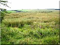
Elsdon Burn
Looking across moorland towards Elsdon Burn.
Image: © Peter McDermott
Taken: 12 Jan 2008
0.24 miles