IMAGES TAKEN NEAR TO
Fenwick, NEWCASTLE UPON TYNE, NE18 0QS
Introduction
This page details the photographs taken nearby to NE18 0QS by members of the Geograph project.
The Geograph project started in 2005 with the aim of publishing, organising and preserving representative images for every square kilometre of Great Britain, Ireland and the Isle of Man.

There are currently over 7.5m images from over14,400 individuals and you can help contribute to the project by visiting https://www.geograph.org.uk
Image Map (Loading...)


Getting Data...Please wait
Leaflet Map data © OpenStreetMap
Images are licensed for reuse under creativecommons.org/licenses/by-sa/2.0
Notes
- Clicking on the map will re-center to the selected point.
- The higher the marker number, the further away the image location is from the centre of the postcode.
Image Listing (5 Images Found)
Images are licensed for reuse under creativecommons.org/licenses/by-sa/2.0
Image
Details
Distance
1
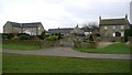
Fenwick Shield
Original farmhouse and steading buildings converted into private houses
Image: © Andrew Curtis
Taken: 1 Mar 2009
0.01 miles
2

Fenwick Shield
What was Fenwick Shield Farm and its out building have been converted into a number of private residences.
Image: © Les Hull
Taken: 1 Mar 2006
0.02 miles
3
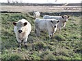
Cattle at Fenwick Shield
The dark ears of these cattle are characteristic of the British White, but the coats appear much woolier than usual for that breed.
Image: © Oliver Dixon
Taken: 23 Nov 2012
0.05 miles
4
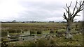
Marshland near Fenwick Shield
View north towards Fenwick. There is a large area of flat land west of Stamfordham, north of the River Pont and extending as far as Fenwick, which is (poorly) drained by a large network of ditches and streams. There was probably a lake here in earlier times and much is still very wet today.
Image: © Andrew Curtis
Taken: 1 Mar 2009
0.15 miles
5
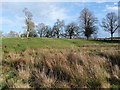
Pea Hill
A modest elevation near Fenwick Shield.
Image: © Oliver Dixon
Taken: 23 Nov 2012
0.20 miles