IMAGES TAKEN NEAR TO
Market Street, NEWCASTLE UPON TYNE, NE1 6ND
Introduction
This page details the photographs taken nearby to Market Street, NE1 6ND by members of the Geograph project.
The Geograph project started in 2005 with the aim of publishing, organising and preserving representative images for every square kilometre of Great Britain, Ireland and the Isle of Man.

There are currently over 7.5m images from over14,400 individuals and you can help contribute to the project by visiting https://www.geograph.org.uk
Image Map (Loading...)


Getting Data...Please wait
Leaflet Map data © OpenStreetMap
Images are licensed for reuse under creativecommons.org/licenses/by-sa/2.0
Notes
- Clicking on the map will re-center to the selected point.
- The higher the marker number, the further away the image location is from the centre of the postcode.
Image Listing (928 Images Found)
Images are licensed for reuse under creativecommons.org/licenses/by-sa/2.0
Image
Details
Distance
1
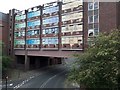
Derelict building over Market Street, Newcastle upon Tyne
The large disused building crosses Market Street. The graphics in the windows highlight its former use as a snooker club.
Image: © Graham Robson
Taken: 14 Jun 2020
0.02 miles
2
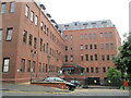
New Croft Centre
New Croft Centre, sexual health clinic in Newcastle Upon Tyne
Image: © Dylan Chester
Taken: 29 Jul 2022
0.02 miles
3
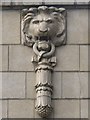
The Plummer Tower (off Crofts Street, NE1) (2)
See Image
Image: © Mike Quinn
Taken: 22 Apr 2015
0.02 miles
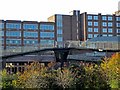
4
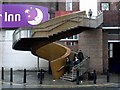
Steps from New Bridge Street to walkway
For a description see here Image
Image: © Andrew Curtis
Taken: 15 Jan 2010
0.03 miles
5
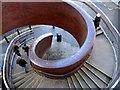
Steps from Walkway to New Bridge Street
The helical stairway made from steel and cedar wood was built and installed by the Jarrow shipbuilders, McNulty as part of the development of Blue Carpet Square in 2000 http://home.freeuk.net/timarchive2/html/body_blue_carpet.htm
For wider view, see Image
Image: © Andrew Curtis
Taken: 11 Nov 2010
0.03 miles
6
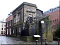
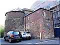
Plummer Tower, off Croft Street
This is a building which incorporates one of the towers on the Newcastle's old Town Walls along with a short length of the wall itself (facing). It was built in late 12C-14C. The rest of the wall, both north and south of the tower was demolished in 1811.
Once called the Carliol Croft Tower, it served as an artillery position at the time of the Civil War. In the 17th century, it was named Cutlers' Tower, used by the Company of Cutlers as a meetings room. In 1749, it was let to the Company of Masons who built the new Palladian west front. They held it into the 20th century, after which it was intermittently used as a dwelling house.
Tyne and Wear HER (1553): Newcastle town wall, Plummer Tower http://www.twsitelines.info
Image: © Andrew Curtis
Taken: 15 Jan 2010
0.03 miles
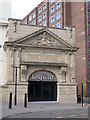
7
The Plummer Tower (off Crofts Street, NE1)
One of the late 13th/early 14th C towers on Newcastle's town walls http://en.wikipedia.org/wiki/Newcastle_town_wall . The west front was added in the mid-18th C. The building is Grade I listed http://list.historicengland.org.uk/resultsingle.aspx?uid=1024884 .
Image: © Mike Quinn
Taken: 22 Apr 2015
0.03 miles
9
Walkways from New Bridge Street
For a wider view see Image
Image: © Andrew Curtis
Taken: 11 Nov 2010
0.04 miles