IMAGES TAKEN NEAR TO
Calder Walk, NEWCASTLE UPON TYNE, NE16 5XS
Introduction
This page details the photographs taken nearby to Calder Walk, NE16 5XS by members of the Geograph project.
The Geograph project started in 2005 with the aim of publishing, organising and preserving representative images for every square kilometre of Great Britain, Ireland and the Isle of Man.

There are currently over 7.5m images from over14,400 individuals and you can help contribute to the project by visiting https://www.geograph.org.uk
Image Map
Images are licensed for reuse under creativecommons.org/licenses/by-sa/2.0
Notes
- Clicking on the map will re-center to the selected point.
- The higher the marker number, the further away the image location is from the centre of the postcode.
Image Listing (10 Images Found)
Images are licensed for reuse under creativecommons.org/licenses/by-sa/2.0
Image
Details
Distance
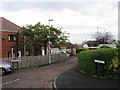
1
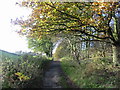
Start of the public path at Hole Lane
At this point along Hole Lane in Sunniside,the road changes to a public path through the fields to Fellside Road in Whickham.
Image: © Robert Graham
Taken: 8 Aug 2012
0.14 miles
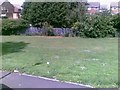
3
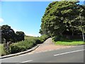
Sandy Lonnen at the junction with Hole Lane Sunniside
Oliver Cromwell is alleged to have marched up Sandy and Clockburn Lonnen with his army. Lonnen is the local word for lane.
Image: © P Glenwright
Taken: 10 Nov 2002
0.19 miles
7
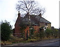
Derelict farmhouse, Clover Hill
On the road to Sunniside, crossing Whickham Fell. For more info and another photo see:
http://www.sunnisidelocalhistorysociety.co.uk/hole-lane.html
Image: © Alan Fearon
Taken: 6 Feb 2006
0.23 miles

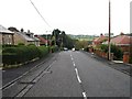
9
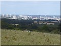
View from the hill above Sunniside
Looking over the Tyne towards the dreaming spires of Newcastle. St James' Stadium Image, home of Newcastle United Football Club can be clearly seen towards the left. Briefly in 2011-12, the Stadium was renamed the "Sport Direct" Stadium.
Image: © Oliver Dixon
Taken: 29 Jul 2020
0.24 miles