IMAGES TAKEN NEAR TO
Oakfield Road, NEWCASTLE UPON TYNE, NE16 5RZ
Introduction
This page details the photographs taken nearby to Oakfield Road, NE16 5RZ by members of the Geograph project.
The Geograph project started in 2005 with the aim of publishing, organising and preserving representative images for every square kilometre of Great Britain, Ireland and the Isle of Man.

There are currently over 7.5m images from over14,400 individuals and you can help contribute to the project by visiting https://www.geograph.org.uk
Image Map
Images are licensed for reuse under creativecommons.org/licenses/by-sa/2.0
Notes
- Clicking on the map will re-center to the selected point.
- The higher the marker number, the further away the image location is from the centre of the postcode.
Image Listing (7 Images Found)
Images are licensed for reuse under creativecommons.org/licenses/by-sa/2.0
Image
Details
Distance

2

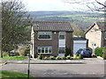
Fellside Methodist Church, Whickham
This church was built on the large housing estate at Fellside in 1980.
Image: © Robert Graham
Taken: 9 Nov 2016
0.10 miles
3
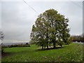
Park trees at Fellside
Fellside is a large private housing development of the late C20 in Whickham. This open area is at the northern end.
Image: © Robert Graham
Taken: 9 Nov 2016
0.18 miles
5
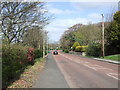
Fellside Road
At the junction with Broadway, looking north.
Image: © Robert Graham
Taken: 9 Nov 2016
0.19 miles
7
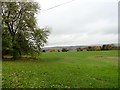
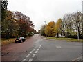
Park at Fellside
This is a view over the park area beside Fellside Road. The estate is built on to o a hill, giving views to the north and west up the Tyne valley.
Image: © Robert Graham
Taken: 9 Nov 2016
0.23 miles