IMAGES TAKEN NEAR TO
Violet Close, NEWCASTLE UPON TYNE, NE16 5DE
Introduction
This page details the photographs taken nearby to Violet Close, NE16 5DE by members of the Geograph project.
The Geograph project started in 2005 with the aim of publishing, organising and preserving representative images for every square kilometre of Great Britain, Ireland and the Isle of Man.

There are currently over 7.5m images from over14,400 individuals and you can help contribute to the project by visiting https://www.geograph.org.uk
Image Map (Loading...)


Getting Data...Please wait
Leaflet Map data © OpenStreetMap
Images are licensed for reuse under creativecommons.org/licenses/by-sa/2.0
Notes
- Clicking on the map will re-center to the selected point.
- The higher the marker number, the further away the image location is from the centre of the postcode.
Image Listing (7 Images Found)
Images are licensed for reuse under creativecommons.org/licenses/by-sa/2.0
Image
Details
Distance
3
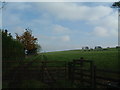
Blackburn Fell
A view of the fell from the Tyne-Wear Trail.
Image: © Steve McShane
Taken: 29 Oct 2005
0.19 miles

6
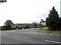
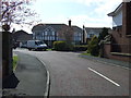
Bottom of Pennyfine Road, Streetgate
This is the junction of Pennyfine Road with the main A692 through the village. The cottages here used to a small metals workshop, and before that, a blacksmiths.
Image: © Robert Graham
Taken: 4 Jul 2014
0.22 miles
7
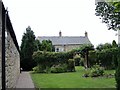
East Farm, Streetgate
There was a farm here for many years, but it ceased to be a working one in the 1990's, when the buildings were converted to residential.
Image: © Robert Graham
Taken: 4 Jul 2014
0.25 miles