IMAGES TAKEN NEAR TO
Kipling Avenue, NEWCASTLE UPON TYNE, NE16 3JB
Introduction
This page details the photographs taken nearby to Kipling Avenue, NE16 3JB by members of the Geograph project.
The Geograph project started in 2005 with the aim of publishing, organising and preserving representative images for every square kilometre of Great Britain, Ireland and the Isle of Man.

There are currently over 7.5m images from over14,400 individuals and you can help contribute to the project by visiting https://www.geograph.org.uk
Image Map
Images are licensed for reuse under creativecommons.org/licenses/by-sa/2.0
Notes
- Clicking on the map will re-center to the selected point.
- The higher the marker number, the further away the image location is from the centre of the postcode.
Image Listing (10 Images Found)
Images are licensed for reuse under creativecommons.org/licenses/by-sa/2.0
Image
Details
Distance
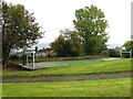
4
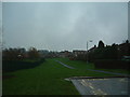
Swalwell Primary School
A small school for 5-11 year olds. The school has room for around 200 pupils.
Image: © Steve McShane
Taken: 3 Dec 2005
0.20 miles
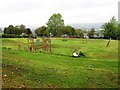
5
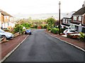
Swalwell
A view from South View Terrace.
Image: © Steve McShane
Taken: 3 Dec 2005
0.20 miles
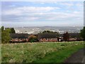
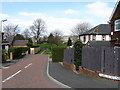
8
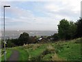
Lower end of Whickham Bank
This road leads north down from the west end of Front Street to Swalwell at the bottom.
Image: © Robert Graham
Taken: 9 Nov 2016
0.23 miles
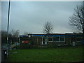
10
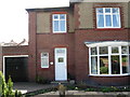
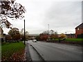
Selwyn, Market Lane, Swalwell
Former home of my Grandparents (McGregor)
Image: © Alex McGregor
Taken: 14 Apr 2010
0.25 miles