IMAGES TAKEN NEAR TO
St. Andrews Street, NEWCASTLE UPON TYNE, NE1 5SF
Introduction
This page details the photographs taken nearby to St. Andrews Street, NE1 5SF by members of the Geograph project.
The Geograph project started in 2005 with the aim of publishing, organising and preserving representative images for every square kilometre of Great Britain, Ireland and the Isle of Man.

There are currently over 7.5m images from over14,400 individuals and you can help contribute to the project by visiting https://www.geograph.org.uk
Image Map (Loading...)


Getting Data...Please wait
Leaflet Map data © OpenStreetMap
Images are licensed for reuse under creativecommons.org/licenses/by-sa/2.0
Notes
- Clicking on the map will re-center to the selected point.
- The higher the marker number, the further away the image location is from the centre of the postcode.
Image Listing (1335 Images Found)
Images are licensed for reuse under creativecommons.org/licenses/by-sa/2.0
Image
Details
Distance
1
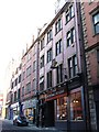
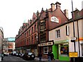
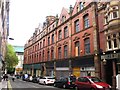
46-70 St. Andrew's Street, NE1
Built c 1902, by Oliver, Leeson and Wood. A five-storey terrace of engineering bricks and stone window surrounds and decorations; the skyline is busy with gables at each end and dormers in between. Shows the location of Image The building is not listed.
The Buildings of Grainger Town - No.208. See Image
Image: © Mike Quinn
Taken: 19 Nov 2013
0.01 miles
2
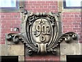
Date stone on 46-70 St. Andrew's Street, NE1
The location of this date stone is shown in Image
The Buildings of Grainger Town - No.208. See Image
Image: © Mike Quinn
Taken: 19 Nov 2013
0.01 miles
3
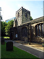
St. Andrew's Church, Newcastle
Said to be the oldest church in Newcastle. Not an easy subject to photograph because of its confined location and surrounding trees. My great, great grandparents, Elizabeth Dixon and William Scaife, were married here in 1844.
Image: © John Lucas
Taken: 15 Aug 2016
0.01 miles
4
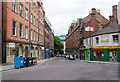
China Town
Looking east down St. Andrew's Street.
Image: © David P Howard
Taken: 29 Aug 2013
0.01 miles
5
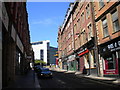
St Andrew's Street
Known to locals by its previous name, 'Darn Crook'.
Tyne and Wear HER (6511): Newcastle, St. Andrews Street (Darn Crook) http://www.twsitelines.info
In the centre of the photo is the Newcastle Arms public house, built in 1903. It is a narrow building but with many interesting features such as the wide curved upper bay window, the first floor multiple-divided window, lower pillars and roof ornaments.
To its left is the 1902 extension to the original 1870s North Eastern Co-op Store which was replaced by the current Art Deco building round the corner on Newgate Street, in the 1930s Image
Image: © Andrew Curtis
Taken: 21 Jan 2010
0.01 miles
6
St Andrew's Street, Newcastle
Part of the Chinese Arch can just be glimpsed in the distance.
Image: © Richard Vince
Taken: 28 Jun 2018
0.01 miles
7
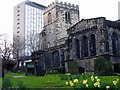
The Parish Church of St Andrew, Newcastle upon Tyne
Considered to be the oldest church in Newcastle dating back to the 12th Century.
http://www.british-history.ac.uk/report.aspx?compid=43357
http://home.freeuk.net/timarchive2/html/standrews.htm
Image: © Andrew Curtis
Taken: 17 Mar 2004
0.01 miles
8
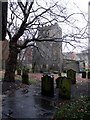
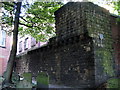
St Andrew's Churchyard
Above left is an overhanging part of the Town Walls which used to run to Andrew Tower, demolished in 1818 to increase room for burials within the churchyard.
Tyne and Wear HER (1541): Newcastle town wall, Andrew Tower http://www.twsitelines.info
Image: © Andrew Curtis
Taken: 15 Jan 2010
0.01 miles
9
Co-operative Stores, service side, St. Andrew's Street, NE1 (2)
Image: © Mike Quinn
Taken: 31 Oct 2013
0.01 miles
10
City Wall, St.Andrew's Churchyard
A particularly fine section of the city wall hidden away at the back of the churchyard
Image: © Alan Fearon
Taken: 23 Sep 2003
0.01 miles