IMAGES TAKEN NEAR TO
Clayton Street West, NEWCASTLE UPON TYNE, NE1 5BY
Introduction
This page details the photographs taken nearby to Clayton Street West, NE1 5BY by members of the Geograph project.
The Geograph project started in 2005 with the aim of publishing, organising and preserving representative images for every square kilometre of Great Britain, Ireland and the Isle of Man.

There are currently over 7.5m images from over14,400 individuals and you can help contribute to the project by visiting https://www.geograph.org.uk
Image Map (Loading...)


Getting Data...Please wait
Leaflet Map data © OpenStreetMap
Images are licensed for reuse under creativecommons.org/licenses/by-sa/2.0
Notes
- Clicking on the map will re-center to the selected point.
- The higher the marker number, the further away the image location is from the centre of the postcode.
Image Listing (1547 Images Found)
Images are licensed for reuse under creativecommons.org/licenses/by-sa/2.0
Image
Details
Distance
1
6-24 Clayton Street West, NE1 (2)
Image: © Mike Quinn
Taken: 29 Oct 2013
0.00 miles
2
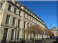
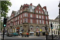
14-24 Clayton Street West, Newcastle
Part of a longish Grainger terrace - his architect probably John Wardle - only the facade of which has been retained in conversion to a housing development in 1979-82. Grade II listed.
Image: © Stephen Richards
Taken: 15 Aug 2012
0.00 miles
3
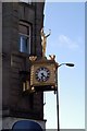
Keeping time
Clock and figure on corner of a building in Newcastle.
Image: © R lee
Taken: 26 Feb 2008
0.01 miles
4

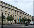
6-24 Clayton Street West, NE1
Built c 1837, probably by John Wardle, for Richard Grainger. Plain Clayton Street design, but these buildings still retain their original wells, bridges and railings to the street, which gives them a much grander appearance than Grainger's other terraces, which usually had shops on the ground floor. The northern section (shown in the photo) was the Crown Hotel (previously the Crown Inn); it closed in 1967. The southern section - see Image - was the Alexandra Temperance Hotel up to the late 1880s, then The Metropole, which closed in 1920 to become the Newcastle Farmers Club. In 1979-82 the buildings were refurbished as housing association flats. The buildings are Grade II listed http://list.historicengland.org.uk/resultsingle.aspx?uid=1355228 .
The Buildings of Grainger Town - No.80. See Image
Image: © Mike Quinn
Taken: 29 Oct 2013
0.01 miles
5
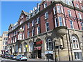
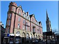
Clarendon House, Clayton Street West, NE1
Built c 1896 by Oliver and Leeson for Joseph Cowen. This handsome Edwardian Arts and Crafts building was originally a temperance hotel, becoming offices in 1923, then converted into flats in 1986-7. Shows the location of Image The building is not listed.
Image: © Mike Quinn
Taken: 22 Apr 2015
0.01 miles
6
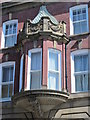
Clarendon House, Clayton Street West, NE1 - oriel window
See Image
Image: © Mike Quinn
Taken: 22 Apr 2015
0.01 miles
7
Clarendon House, Clayton Street West, NE1 (2)
Image: © Mike Quinn
Taken: 22 Apr 2015
0.01 miles
8
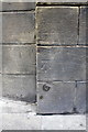
Benchmark on Clarendon House
Ordnance Survey cut mark benchmark described on the Bench Mark Database at http://www.bench-marks.org.uk/bm41951
Image: © Roger Templeman
Taken: 21 May 2012
0.01 miles
9
Clarendon House
The businesses housed in the building include Beatdown Records and LB Indian & Bangladeshi Restaurant. There is an OS benchmark Image on the corner of the building.
Image: © Roger Templeman
Taken: 21 May 2012
0.01 miles
10
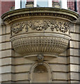
Detail of Clarendon House, Clayton Street West, Newcastle
Decorative corbel supporting a corner oriel.
Full view: Image
Image: © Stephen Richards
Taken: 15 Aug 2012
0.01 miles